IMAGES TAKEN NEAR TO
Grimsey Lane, GILLINGHAM, SP8 5JB
Introduction
This page details the photographs taken nearby to Grimsey Lane, SP8 5JB by members of the Geograph project.
The Geograph project started in 2005 with the aim of publishing, organising and preserving representative images for every square kilometre of Great Britain, Ireland and the Isle of Man.

There are currently over 7.5m images from over14,400 individuals and you can help contribute to the project by visiting https://www.geograph.org.uk
Image Map
Images are licensed for reuse under creativecommons.org/licenses/by-sa/2.0
Notes
- Clicking on the map will re-center to the selected point.
- The higher the marker number, the further away the image location is from the centre of the postcode.
Image Listing (10 Images Found)
Images are licensed for reuse under creativecommons.org/licenses/by-sa/2.0
Image
Details
Distance
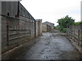
2
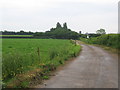
Grimsey Lane
A view looking to the southeast along Grimsey Lane. Westfield Dairy can be seen in the distance.
Image: © Phil Williams
Taken: 13 Jun 2007
0.13 miles
3
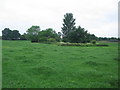
Farmland near Feltham Farm
A view looking to the northwest across farmland near Feltham Farm, towards a small pond hidden in the undergrowth.
Image: © Phil Williams
Taken: 13 Jun 2007
0.16 miles
4
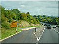
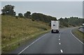
Silton : A303
The layby will be closed from September 17 for three weeks.
Image: © Lewis Clarke
Taken: 12 Sep 2020
0.18 miles
5
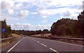
A303 parking area south of Bourton
Image: © Julian P Guffogg
Taken: 12 Aug 2013
0.20 miles
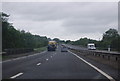
6
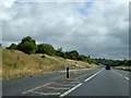
Lay-by on A303 eastbound south-east of Bourton
The lay-by is in a shallow cutting
Image: © David Smith
Taken: 10 Aug 2014
0.21 miles
7

Dairy farm buildings
A new milking complex being built
Image: © derek menzies
Taken: 15 Sep 2011
0.22 miles
9
Footpath to West Bourton.
A view looking to the west along the public footpath from Grimsey Lane to West Bourton. The start of the footpath runs through the premises of Westfield Dairy, the sheds of which can be seen on the left.
Image: © Phil Williams
Taken: 13 Jun 2007
0.24 miles