IMAGES TAKEN NEAR TO
Roads Lane, GILLINGHAM, SP8 5FF
Introduction
This page details the photographs taken nearby to Roads Lane, SP8 5FF by members of the Geograph project.
The Geograph project started in 2005 with the aim of publishing, organising and preserving representative images for every square kilometre of Great Britain, Ireland and the Isle of Man.

There are currently over 7.5m images from over14,400 individuals and you can help contribute to the project by visiting https://www.geograph.org.uk
Image Map
Images are licensed for reuse under creativecommons.org/licenses/by-sa/2.0
Notes
- Clicking on the map will re-center to the selected point.
- The higher the marker number, the further away the image location is from the centre of the postcode.
Image Listing (9 Images Found)
Images are licensed for reuse under creativecommons.org/licenses/by-sa/2.0
Image
Details
Distance

2
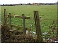
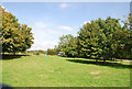
Footpath beside the A30
The footpath takes walkers to Lower Nyland Farm.
Image: © Maigheach-gheal
Taken: 8 Feb 2009
0.12 miles
3
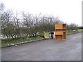
Flytip beside the A30
Found in the layby at Five Bridges on the A30.
Image: © Maigheach-gheal
Taken: 8 Feb 2009
0.19 miles
4
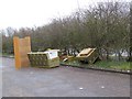
Flytip beside the A30
Someone has bumped all this in the layby at Five Bridges.
Image: © Maigheach-gheal
Taken: 8 Feb 2009
0.19 miles
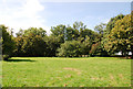
7
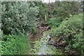
Very overgrown River Cale at Five Bridges
Image: © David Martin
Taken: 27 May 2017
0.23 miles
8
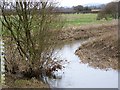
The Cale at Five Bridges
The Cale is a tributary of the River Stour.
Image: © Maigheach-gheal
Taken: 8 Feb 2009
0.24 miles
9
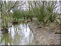
The River Cale at Five Bridges
Looking downstream of one of the tributaries of the River Stour.
Image: © Maigheach-gheal
Taken: 8 Feb 2009
0.25 miles