IMAGES TAKEN NEAR TO
Tunnel Head, GILLINGHAM, SP8 5EA
Introduction
This page details the photographs taken nearby to Tunnel Head, SP8 5EA by members of the Geograph project.
The Geograph project started in 2005 with the aim of publishing, organising and preserving representative images for every square kilometre of Great Britain, Ireland and the Isle of Man.

There are currently over 7.5m images from over14,400 individuals and you can help contribute to the project by visiting https://www.geograph.org.uk
Image Map
Images are licensed for reuse under creativecommons.org/licenses/by-sa/2.0
Notes
- Clicking on the map will re-center to the selected point.
- The higher the marker number, the further away the image location is from the centre of the postcode.
Image Listing (9 Images Found)
Images are licensed for reuse under creativecommons.org/licenses/by-sa/2.0
Image
Details
Distance
3
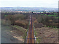
The Waterloo to Exeter Line
The railway line has just left the tunnel that runs underneath the Sandley Stud and heads out across the Blackmoor Vale.
Image: © Maigheach-gheal
Taken: 26 Feb 2007
0.10 miles
4
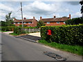
Sandley: postbox № SP8 78
This small postbox stands directly on the gridline boundary and is emptied finally at 4:30pm on weekdays and at 7:45am on Saturdays.
Image: © Chris Downer
Taken: 8 Aug 2009
0.12 miles