IMAGES TAKEN NEAR TO
Horsefields, GILLINGHAM, SP8 4UQ
Introduction
This page details the photographs taken nearby to Horsefields, SP8 4UQ by members of the Geograph project.
The Geograph project started in 2005 with the aim of publishing, organising and preserving representative images for every square kilometre of Great Britain, Ireland and the Isle of Man.

There are currently over 7.5m images from over14,400 individuals and you can help contribute to the project by visiting https://www.geograph.org.uk
Image Map
Images are licensed for reuse under creativecommons.org/licenses/by-sa/2.0
Notes
- Clicking on the map will re-center to the selected point.
- The higher the marker number, the further away the image location is from the centre of the postcode.
Image Listing (20 Images Found)
Images are licensed for reuse under creativecommons.org/licenses/by-sa/2.0
Image
Details
Distance
1
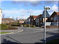
Entrance Road to Horsefields.
Estate built in the early 90's. Trees and Bushes were planted by the developer and these are now well established. The estate which is off Gyllas Way is within walking distance of the town centre and yet is only a short distance from open countryside.
Image: © Clive Warneford
Taken: 6 Feb 2008
0.04 miles
2
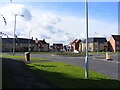
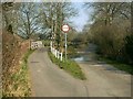
Peacemarsh Roundabout.
Taken from Gyllas Way, to the left is the road to the town centre of Gillingham, to the right is the road to Mere. New houses of tasteful design accessed opposite the photographer.
Image: © Clive Warneford
Taken: 6 Feb 2008
0.09 miles
3
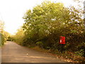
Gillingham: postbox № SP8 53, Colesbrook
A small postbox serving the northern fringe of the town, emptied finally at 5:15pm on weekdays and at 10am on Saturdays.
Image: © Chris Downer
Taken: 18 Oct 2009
0.10 miles
4
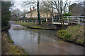
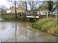
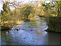
Gillingham Ford
This ford on Shreen Water is found at Colesbrook near Gillingham.
Image: © John Walton
Taken: 18 Mar 2016
0.13 miles
5
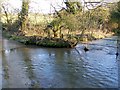
Just too deep to drive through!
This is the Ford near to Purns Mill, the river is known as Shreen Water. After a considerable amount of rain, I was surprised not to see it both deeper and faster flowing.
Image: © Clive Warneford
Taken: 23 Nov 2012
0.13 miles
7
Swollen Ford!
Rather too deep to drive through in anything other than a tractor, the Ford near Gillingham was really only good for photographing on this day.
Image: © Clive Warneford
Taken: 12 Jan 2008
0.14 miles
8
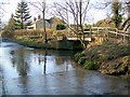
Shreen Water
Footbridge beside the ford through Shreen Water.
Image: © Maigheach-gheal
Taken: 1 Feb 2009
0.14 miles
9
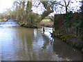
Shreen Water
Shreen Water is a tributary of the River Stour.
Image: © Maigheach-gheal
Taken: 1 Feb 2009
0.15 miles
10
Ford near Milton on Stour
Ford through Shreen Water.
Image: © Maigheach-gheal
Taken: 1 Feb 2009
0.15 miles