IMAGES TAKEN NEAR TO
Shaftesbury Road, GILLINGHAM, SP8 4LL
Introduction
This page details the photographs taken nearby to Shaftesbury Road, SP8 4LL by members of the Geograph project.
The Geograph project started in 2005 with the aim of publishing, organising and preserving representative images for every square kilometre of Great Britain, Ireland and the Isle of Man.

There are currently over 7.5m images from over14,400 individuals and you can help contribute to the project by visiting https://www.geograph.org.uk
Image Map
Images are licensed for reuse under creativecommons.org/licenses/by-sa/2.0
Notes
- Clicking on the map will re-center to the selected point.
- The higher the marker number, the further away the image location is from the centre of the postcode.
Image Listing (3 Images Found)
Images are licensed for reuse under creativecommons.org/licenses/by-sa/2.0
Image
Details
Distance
1
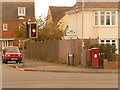
Gillingham: postbox № SP8 71, Shaftesbury Road
This Elizabeth II-reign postbox, backing on to a new housing development and facing new traffic lights as a result, is emptied finally at 5:30pm on weekdays and at 11:30am on Saturdays.
Image: © Chris Downer
Taken: 18 Oct 2009
0.04 miles
2
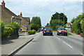
B3081 Shaftesbury Road, Ham Common
The fringes of Gillingham.
Image: © Robin Webster
Taken: 10 Jun 2018
0.12 miles
3
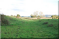
King's Court Palace (site of)
No remains are visible here, just the mounds to show some of the shape.
Image: © Toby
Taken: 19 Oct 2007
0.23 miles