IMAGES TAKEN NEAR TO
Ludwell, SHAFTESBURY, SP7 9NF
Introduction
This page details the photographs taken nearby to SP7 9NF by members of the Geograph project.
The Geograph project started in 2005 with the aim of publishing, organising and preserving representative images for every square kilometre of Great Britain, Ireland and the Isle of Man.

There are currently over 7.5m images from over14,400 individuals and you can help contribute to the project by visiting https://www.geograph.org.uk
Image Map
Images are licensed for reuse under creativecommons.org/licenses/by-sa/2.0
Notes
- Clicking on the map will re-center to the selected point.
- The higher the marker number, the further away the image location is from the centre of the postcode.
Image Listing (26 Images Found)
Images are licensed for reuse under creativecommons.org/licenses/by-sa/2.0
Image
Details
Distance
2
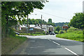
A30 heading west at crossroads, Peckons Hill
Image: © Robin Webster
Taken: 10 Jun 2018
0.11 miles
3
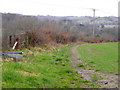
Footpath, Ludwell
Footpath from the A30 towards Lower Berrycourt.
Image: © Maigheach-gheal
Taken: 25 Feb 2011
0.13 miles
4
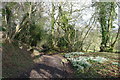
Snowdrops on Back Horse Hill Lane
A couple of weeks ahead of the snowdrops in the north of England
Image: © Tim Heaton
Taken: 11 Feb 2020
0.13 miles
5
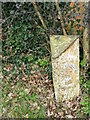
Milepost, Ludwell
The milepost is beside the A30.
Milestones/mileposts did not come into general use until the Turnpike Act of 1766 made them compulsory on turnpike roads, these roads were built by private enterprise under licence from the Government and maintained by tolls on those who used them. Before this Act milestones/mileposts were put up occasionally, often as charitable acts and commemorations. Many Turnpike Act stones/posts still exist. They are usually 2-3 ft high, with the initial letter or abbreviation of the nearest market town shown on two faces, and the distance from it.
Image: © Maigheach-gheal
Taken: 25 Feb 2011
0.14 miles
6
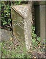
Old Milepost by the A30, Peckons Hill, Ludwell
Cast iron post by the A30, in parish of DONHEAD ST MARY (SALISBURY District), Ludwell; East of village next to the junction with Dennis Lane, on the verge, on South side of road. Cockey iron casting, erected by the Whitesheet turnpike trust in the 19th century.
Inscription reads:-
: SHASTON / 3 : : DONHEAD ST MARY : : SALISBURY / 17 :
Milestone Society National ID: WI_SHSA03.
Image: © M Faherty
Taken: 18 May 2007
0.14 miles
7
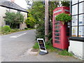
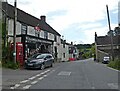
Telephone box, Ludwell
A K6 type telephone box beside the A30 near the post office.
In 1935, the Post Office commissioned a new kiosk from Sir Giles Gilbert Scott to celebrate the Jubilee of King George V. The K6 Jubilee Kiosk, as it is known, was similar to the K2 box, being made of cast iron and painted red but was 25% lighter in weight. By the end of the 1930s there were 20,000 K6 telephone boxes in use all over the UK.
Image: © Maigheach-gheal
Taken: 30 Aug 2010
0.14 miles