IMAGES TAKEN NEAR TO
Sedgehill, SHAFTESBURY, SP7 9JE
Introduction
This page details the photographs taken nearby to SP7 9JE by members of the Geograph project.
The Geograph project started in 2005 with the aim of publishing, organising and preserving representative images for every square kilometre of Great Britain, Ireland and the Isle of Man.

There are currently over 7.5m images from over14,400 individuals and you can help contribute to the project by visiting https://www.geograph.org.uk
Image Map
Images are licensed for reuse under creativecommons.org/licenses/by-sa/2.0
Notes
- Clicking on the map will re-center to the selected point.
- The higher the marker number, the further away the image location is from the centre of the postcode.
Image Listing (8 Images Found)
Images are licensed for reuse under creativecommons.org/licenses/by-sa/2.0
Image
Details
Distance
1

Sweetwell Farm
Lane and Farm at Sweetwell
Image: © Graham Burnett
Taken: 25 Nov 2006
0.09 miles
2
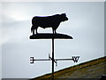
Weather vane, Sweetwell Farm
As long as humans have farmed the land, sailed the seas and contemplated their place in nature, the wind has played a key role in their speculations. It was interpreting the wind's changing direction that helped our ancestors predict the coming weather and survive.
Image: © Maigheach-gheal
Taken: 25 Feb 2011
0.12 miles
3
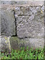
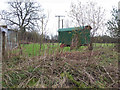
Bench Mark, Sweetwell Farm
The bench mark is to be found on the north east wall of the farm building. For a wider view of the building Image and for further information on the cut mark http://www.bench-marks.org.uk/bm37240
A bench mark is an Ordnance Survey arrowhead sign found on walls, bridges, churches and specially erected triangulation pillars where the altitude above sea-level has been accurately measured by surveyors. The arrowhead points to a horizontal line above it which marks the exact altitude.
With rivets and pivots there is no datum (horizontal line) cut, the pointed-to horizontal surface defining the datum height.
Image: © Maigheach-gheal
Taken: 25 Feb 2011
0.13 miles
5
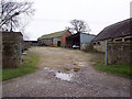
Farm buildings, Sweetwell Farm
Some of the buildings at Sweetwell Farm. There is an Ordnance Survey bench mark on the north east angle of the building nearest the road.
Image: © Maigheach-gheal
Taken: 25 Feb 2011
0.14 miles
6
Shepherds caravan at Sweetwell Farm near Sedgehill
Image: © Maigheach-gheal
Taken: 14 Feb 2007
0.16 miles
7
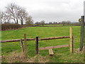
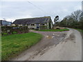
Footpath near Sedgehill
The footpath from Crate Lane to Pitts Lane.
Image: © Maigheach-gheal
Taken: 25 Feb 2011
0.18 miles
8
Footpath near Sweetwell Farm, Sedgehill
Image: © Maigheach-gheal
Taken: 9 Mar 2007
0.19 miles