IMAGES TAKEN NEAR TO
Chantry Mews, SP7 9FA
Introduction
This page details the photographs taken nearby to Chantry Mews, SP7 9FA by members of the Geograph project.
The Geograph project started in 2005 with the aim of publishing, organising and preserving representative images for every square kilometre of Great Britain, Ireland and the Isle of Man.

There are currently over 7.5m images from over14,400 individuals and you can help contribute to the project by visiting https://www.geograph.org.uk
Image Map
Images are licensed for reuse under creativecommons.org/licenses/by-sa/2.0
Notes
- Clicking on the map will re-center to the selected point.
- The higher the marker number, the further away the image location is from the centre of the postcode.
Image Listing (62 Images Found)
Images are licensed for reuse under creativecommons.org/licenses/by-sa/2.0
Image
Details
Distance
3
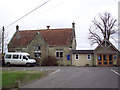
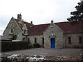
Motcombe Primary School
CoE Aided School, next to St. Mary's. The original building is dated 1874; more modern buildings are out of sight, at the back. http://www.motcombe.dorset.sch.uk/
Image: © Mike Faherty
Taken: 30 Mar 2013
0.10 miles
4
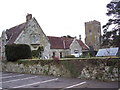
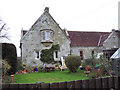
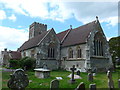
St Mary's Church and Motcombe School
Image: © Maigheach-gheal
Taken: 28 Jan 2007
0.11 miles
7
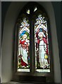
St Mary, Motcombe: stained glass window (a)
Image: © Basher Eyre
Taken: 8 Jun 2015
0.12 miles
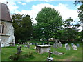
9
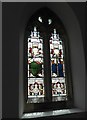
St Mary, Motcombe: stained glass window (b)
Image: © Basher Eyre
Taken: 8 Jun 2015
0.13 miles
