IMAGES TAKEN NEAR TO
Jenkins Corner, SHAFTESBURY, SP7 9DD
Introduction
This page details the photographs taken nearby to Jenkins Corner, SP7 9DD by members of the Geograph project.
The Geograph project started in 2005 with the aim of publishing, organising and preserving representative images for every square kilometre of Great Britain, Ireland and the Isle of Man.

There are currently over 7.5m images from over14,400 individuals and you can help contribute to the project by visiting https://www.geograph.org.uk
Image Map
Images are licensed for reuse under creativecommons.org/licenses/by-sa/2.0
Notes
- Clicking on the map will re-center to the selected point.
- The higher the marker number, the further away the image location is from the centre of the postcode.
Image Listing (15 Images Found)
Images are licensed for reuse under creativecommons.org/licenses/by-sa/2.0
Image
Details
Distance
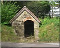
1
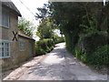
Lane looking west from the well at Donhead St Mary
Image: © Rob Purvis
Taken: 7 May 2010
0.08 miles
2
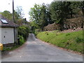
Cycle route heading north west from the well at Donhead St Mary
Image: © Rob Purvis
Taken: 7 May 2010
0.09 miles
3
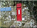
Edward VII postbox, Donhead St Mary
In the limestone wall at North Down.
Image: © Maigheach-gheal
Taken: 19 Feb 2009
0.10 miles
6
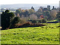
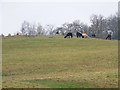
Fields near Donhead St Mary
Looking across small grazing fields towards St Mary's Church.
Image: © Maigheach-gheal
Taken: 26 Nov 2010
0.14 miles
7
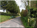
Cycle route heading east from the well at Donhead St Mary
Image: © Rob Purvis
Taken: 7 May 2010
0.17 miles
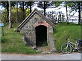
8
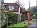
Telephone box, Donhead St Mary
K6 style telephone kiosk.
Image: © Maigheach-gheal
Taken: 19 Feb 2009
0.18 miles
9
Alpaca beside Berry Hill Lane
Alpaca at Shute Farm. Interestingly one of them is wearing a rug.
Image: © Maigheach-gheal
Taken: 19 Feb 2009
0.20 miles
10
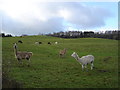
Alpacas on Shute Farm
Just below Donhead St Mary
Image: © Toby
Taken: 21 Jan 2007
0.20 miles