IMAGES TAKEN NEAR TO
Motcombe, SHAFTESBURY, SP7 9BX
Introduction
This page details the photographs taken nearby to SP7 9BX by members of the Geograph project.
The Geograph project started in 2005 with the aim of publishing, organising and preserving representative images for every square kilometre of Great Britain, Ireland and the Isle of Man.

There are currently over 7.5m images from over14,400 individuals and you can help contribute to the project by visiting https://www.geograph.org.uk
Image Map
Images are licensed for reuse under creativecommons.org/licenses/by-sa/2.0
Notes
- Clicking on the map will re-center to the selected point.
- The higher the marker number, the further away the image location is from the centre of the postcode.
Image Listing (4 Images Found)
Images are licensed for reuse under creativecommons.org/licenses/by-sa/2.0
Image
Details
Distance
1
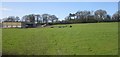
Barn and field, Knapp Hill
Looking up a hillside from a train on the railway line between Gillingham and Tisbury. The black objects are cattle.
Image: © Derek Harper
Taken: 29 Apr 2013
0.04 miles
2
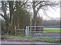
Footpath to Motcombe from Knapp Hill
Image: © Maigheach-gheal
Taken: 9 Mar 2007
0.12 miles
4
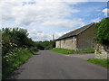
Culverhouse Farm
A view looking to the northwest along the lane between Knapp Hill and North End, towards the entrance to Culverhouse Farm.
Image: © Phil Williams
Taken: 22 Jul 2007
0.24 miles