IMAGES TAKEN NEAR TO
Station Road, SHAFTESBURY, SP7 9BU
Introduction
This page details the photographs taken nearby to Station Road, SP7 9BU by members of the Geograph project.
The Geograph project started in 2005 with the aim of publishing, organising and preserving representative images for every square kilometre of Great Britain, Ireland and the Isle of Man.

There are currently over 7.5m images from over14,400 individuals and you can help contribute to the project by visiting https://www.geograph.org.uk
Image Map
Images are licensed for reuse under creativecommons.org/licenses/by-sa/2.0
Notes
- Clicking on the map will re-center to the selected point.
- The higher the marker number, the further away the image location is from the centre of the postcode.
Image Listing (4 Images Found)
Images are licensed for reuse under creativecommons.org/licenses/by-sa/2.0
Image
Details
Distance
1
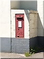
Semley: postbox № SP7 7
A George V-reign postbox set into a pillar which has been painted to match the adjoining building. It serves the small industrial area around the site of Semley Station (the line still runs but the station is long gone).
Image: © Chris Downer
Taken: 8 Jun 2013
0.04 miles
2
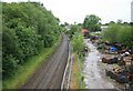
Waterloo - Exeter line site of Semley Station
Looking westwards the former station house is in the distance. The station closed on the 17th March 1966.
Image: © roger geach
Taken: 2 Jul 2010
0.14 miles
3
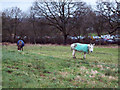
Grazing Donkeys at Semley Common
These donkeys are about forty years old and have grazed on the common for most of their lives. The srapyard is in the background.
Image: © Maigheach-gheal
Taken: 17 Jan 2007
0.21 miles
4
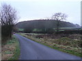
Road to Semley
The dome-shaped wood is Coppit Dennis.
Image: © Jonathan Billinger
Taken: 28 Nov 2008
0.23 miles