IMAGES TAKEN NEAR TO
Semley, SHAFTESBURY, SP7 9AW
Introduction
This page details the photographs taken nearby to SP7 9AW by members of the Geograph project.
The Geograph project started in 2005 with the aim of publishing, organising and preserving representative images for every square kilometre of Great Britain, Ireland and the Isle of Man.

There are currently over 7.5m images from over14,400 individuals and you can help contribute to the project by visiting https://www.geograph.org.uk
Image Map
Images are licensed for reuse under creativecommons.org/licenses/by-sa/2.0
Notes
- Clicking on the map will re-center to the selected point.
- The higher the marker number, the further away the image location is from the centre of the postcode.
Image Listing (8 Images Found)
Images are licensed for reuse under creativecommons.org/licenses/by-sa/2.0
Image
Details
Distance
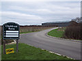
3
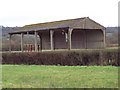
Barn conversion taking place at Chaldicott's Farm
Image: © Maigheach-gheal
Taken: 9 Mar 2007
0.05 miles
4
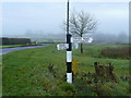
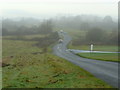
Semley Common signpost
The road to Semley stretches away into the distance.
Image: © Jonathan Billinger
Taken: 28 Nov 2008
0.08 miles
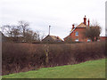
5
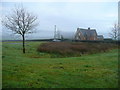
House on Semley Common
Looking south on a misty late-November morning.
Image: © Jonathan Billinger
Taken: 28 Nov 2008
0.10 miles
7
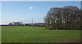
Road to Sedgehill
Looking west across a misty Semley Common.
Image: © Jonathan Billinger
Taken: 28 Nov 2008
0.16 miles
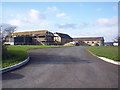
8
Small wood near Semley
This small square patch of mature woodland is enclosed on three sides but not this southern side. Chaldicott's Cottages, in the background, are in Image
Image: © Derek Harper
Taken: 29 Apr 2013
0.24 miles