IMAGES TAKEN NEAR TO
Semley, SHAFTESBURY, SP7 9AP
Introduction
This page details the photographs taken nearby to SP7 9AP by members of the Geograph project.
The Geograph project started in 2005 with the aim of publishing, organising and preserving representative images for every square kilometre of Great Britain, Ireland and the Isle of Man.

There are currently over 7.5m images from over14,400 individuals and you can help contribute to the project by visiting https://www.geograph.org.uk
Image Map
Images are licensed for reuse under creativecommons.org/licenses/by-sa/2.0
Notes
- Clicking on the map will re-center to the selected point.
- The higher the marker number, the further away the image location is from the centre of the postcode.
Image Listing (8 Images Found)
Images are licensed for reuse under creativecommons.org/licenses/by-sa/2.0
Image
Details
Distance
1
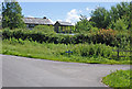
Track to Semley Gates Crossing
The white gate of the level crossing can just be seen between the houses.
Image: © David Martin
Taken: 5 Feb 2023
0.01 miles
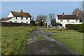
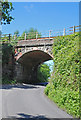
3
Sem Hill
Well, the junction to Sem Hill. Which does not seem to be much of a hill. Maybe just a name for the posh end of Semley.
Image: © Toby
Taken: 7 Jul 2007
0.08 miles
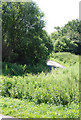
5
Footpath and drive to The Grange, Semley
The footpath turns off to the left by the post and crosses the stream by a small bridge.
Image: © David Martin
Taken: 5 Feb 2023
0.11 miles
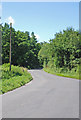
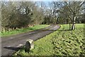
6
Road to Sem Hill
Sem Hill seems to be simply a few houses outside the main village of Semley.
Image: © Toby
Taken: 7 Jul 2007
0.12 miles