IMAGES TAKEN NEAR TO
St. Andrews View, SHAFTESBURY, SP7 0QY
Introduction
This page details the photographs taken nearby to St. Andrews View, SP7 0QY by members of the Geograph project.
The Geograph project started in 2005 with the aim of publishing, organising and preserving representative images for every square kilometre of Great Britain, Ireland and the Isle of Man.

There are currently over 7.5m images from over14,400 individuals and you can help contribute to the project by visiting https://www.geograph.org.uk
Image Map
Images are licensed for reuse under creativecommons.org/licenses/by-sa/2.0
Notes
- Clicking on the map will re-center to the selected point.
- The higher the marker number, the further away the image location is from the centre of the postcode.
Image Listing (104 Images Found)
Images are licensed for reuse under creativecommons.org/licenses/by-sa/2.0
Image
Details
Distance
1
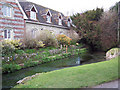
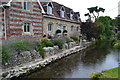
Fontmell Brook, Fontmell Magna
The Domesday Book (1086) mentions the Fontmell Brook powering three mills.
Image: © Maigheach-gheal
Taken: 18 Mar 2007
0.07 miles
2
War Memorial, Church Street, Fontmell Magna
Image: © Maigheach-gheal
Taken: 18 Mar 2007
0.08 miles
3
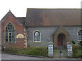
Methodist Church, Fontmell Magna
Situated next to the village store and post office on the A350 south of Shaftesbury.
Image: © michael ely
Taken: 8 Oct 2006
0.09 miles
4
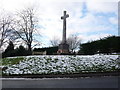
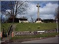
Fontmell Magna: the war memorial
The war memorial stands on the corner of Church and North Streets, opposite the Image
Image: © Chris Downer
Taken: 7 Feb 2009
0.10 miles
5
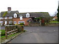
House overlooking Collyer's Brook
The first drops of a torrential thunderstorm can be seen on the surface of the water.
Image: © David Martin
Taken: 13 Aug 2020
0.11 miles
6
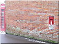
Fontmell Magna: postbox and phone box
A view of the Image in the side wall of the post office, with the telephone box in the picture as well
Image: © Chris Downer
Taken: 7 Feb 2009
0.11 miles
7
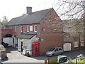
Fontmell Magna: the post office
Looking down on the post office and village store, from the little lump on which the war memorial stands prominently. See Image for a close-up of the postbox, which is just visible at the back end of the parked car.
Image: © Chris Downer
Taken: 30 Mar 2014
0.12 miles
8
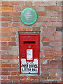
Fontmell Magna: postbox № SP7 28, Church Street
This George VI-reign postbox is known as a 'Ludlow' box, named after its designer, and these were specifically designed for walls of sub-post offices. It is indeed in the wall of the post office (see Image). Above is a 2009 'Best Kept Large Village' award from Dorset County Council.
Image: © Chris Downer
Taken: 30 Mar 2014
0.12 miles
9
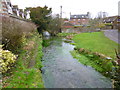
Fontmell Magna, brook
Fontmell Brook, looking upstream. The brook is flowing strongly as it has just passed through a weir at Image
Image: © Mike Faherty
Taken: 3 Feb 2013
0.12 miles
10
Fontmell Magna, former mill
Early C19 mill and millhouse on Church Street; listed by English Heritage: http://www.imagesofengland.org.uk/Details/Default.aspx?id=103137&mode=adv
Image: © Mike Faherty
Taken: 3 Feb 2013
0.12 miles