IMAGES TAKEN NEAR TO
West Orchard, SHAFTESBURY, SP7 0LN
Introduction
This page details the photographs taken nearby to SP7 0LN by members of the Geograph project.
The Geograph project started in 2005 with the aim of publishing, organising and preserving representative images for every square kilometre of Great Britain, Ireland and the Isle of Man.

There are currently over 7.5m images from over14,400 individuals and you can help contribute to the project by visiting https://www.geograph.org.uk
Image Map
Images are licensed for reuse under creativecommons.org/licenses/by-sa/2.0
Notes
- Clicking on the map will re-center to the selected point.
- The higher the marker number, the further away the image location is from the centre of the postcode.
Image Listing (3 Images Found)
Images are licensed for reuse under creativecommons.org/licenses/by-sa/2.0
Image
Details
Distance
1
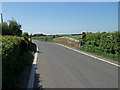
Bridge over Key Brook
On the B3091 near to West Orchard.
Image: © Mike Searle
Taken: 1 May 2007
0.10 miles
2
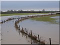
Key Brook
After weeks of prolonged rain and then heavy snowfall the small brook has now burst its banks and has flooded the surrounding fields.
Image: © Maigheach-gheal
Taken: 16 Jan 2010
0.18 miles
3
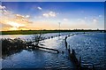
Key Brook Flood: View from the B 3091 Road Bridge
Image: © Mr Eugene Birchall
Taken: 30 Jan 2013
0.20 miles