IMAGES TAKEN NEAR TO
Hartgrove, SHAFTESBURY, SP7 0JY
Introduction
This page details the photographs taken nearby to SP7 0JY by members of the Geograph project.
The Geograph project started in 2005 with the aim of publishing, organising and preserving representative images for every square kilometre of Great Britain, Ireland and the Isle of Man.

There are currently over 7.5m images from over14,400 individuals and you can help contribute to the project by visiting https://www.geograph.org.uk
Image Map
Images are licensed for reuse under creativecommons.org/licenses/by-sa/2.0
Notes
- Clicking on the map will re-center to the selected point.
- The higher the marker number, the further away the image location is from the centre of the postcode.
Image Listing (3 Images Found)
Images are licensed for reuse under creativecommons.org/licenses/by-sa/2.0
Image
Details
Distance
1
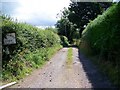
Drive to Hartgrove Farm
The drive leads to the dairy unit.
Image: © Maigheach-gheal
Taken: 2 Aug 2008
0.17 miles
2
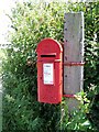
Edward VII Postbox, Hartgrove
Found at the entrance to the driveway to Hartgrove Farm.
Image: © Maigheach-gheal
Taken: 2 Aug 2008
0.18 miles
3
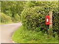
Hartgrove: postbox № SP7 26
A small Edward VII-reign postbox clasped to a wooden post and serving eastern Hartgrove. It is emptied finally at 4pm on weekdays and at 9am on Saturdays.
Image: © Chris Downer
Taken: 18 Jul 2009
0.19 miles