IMAGES TAKEN NEAR TO
Twyford, SHAFTESBURY, SP7 0JF
Introduction
This page details the photographs taken nearby to SP7 0JF by members of the Geograph project.
The Geograph project started in 2005 with the aim of publishing, organising and preserving representative images for every square kilometre of Great Britain, Ireland and the Isle of Man.

There are currently over 7.5m images from over14,400 individuals and you can help contribute to the project by visiting https://www.geograph.org.uk
Image Map
Images are licensed for reuse under creativecommons.org/licenses/by-sa/2.0
Notes
- Clicking on the map will re-center to the selected point.
- The higher the marker number, the further away the image location is from the centre of the postcode.
Image Listing (5 Images Found)
Images are licensed for reuse under creativecommons.org/licenses/by-sa/2.0
Image
Details
Distance
1
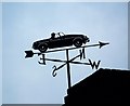
Weather vane, Higher Green Farm
For centuries weathervanes have kept people in touch with the elements, signalling those shifts in the wind, which bring changes in the weather. This simple device has grown into a charming English tradition which can say something about their owners, adding interest to the landscape.
Image: © Maigheach-gheal
Taken: 28 Sep 2008
0.06 miles
2

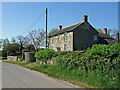
Lane, Twyford
The lane runs past Higher Green Farm at this point.
Image: © Maigheach-gheal
Taken: 28 Sep 2008
0.07 miles
3
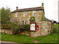
Twyford: postbox № SP7 14
This Elizabeth II-reign postbox is set into the frontage wall of Twyford Farm farmhouse. It is emptied finally at 4pm on weekdays and at 7:30am on Saturday mornings.
Image: © Chris Downer
Taken: 18 Jul 2009
0.11 miles
4
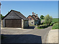
Farm at Twyford
Small farm situated in the hamlet of Twyford, about 3 miles south of Shaftesbury.
Image: © Mike Searle
Taken: 1 May 2007
0.13 miles