IMAGES TAKEN NEAR TO
Barnfield, SHAFTESBURY, SP7 0DH
Introduction
This page details the photographs taken nearby to Barnfield, SP7 0DH by members of the Geograph project.
The Geograph project started in 2005 with the aim of publishing, organising and preserving representative images for every square kilometre of Great Britain, Ireland and the Isle of Man.

There are currently over 7.5m images from over14,400 individuals and you can help contribute to the project by visiting https://www.geograph.org.uk
Image Map
Images are licensed for reuse under creativecommons.org/licenses/by-sa/2.0
Notes
- Clicking on the map will re-center to the selected point.
- The higher the marker number, the further away the image location is from the centre of the postcode.
Image Listing (4 Images Found)
Images are licensed for reuse under creativecommons.org/licenses/by-sa/2.0
Image
Details
Distance
1
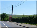
Telephone box, Cann Common
Beside the B3081 stands a K6 type telephone box.
In 1935, the Post Office commissioned a new kiosk from Sir Giles Gilbert Scott to celebrate the Jubilee of King George V. The K6 Jubilee Kiosk, as it is known, was similar to the K2 box, being made of cast iron and painted red but was 25% lighter in weight. By the end of the 1930s there were 20,000 K6 telephone boxes in use all over the UK.
Image: © Maigheach-gheal
Taken: 16 Aug 2010
0.04 miles
2
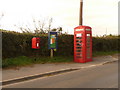
Cann Common: postbox № SP7 19 and phone
Two red objects on the B3081, Britain's tenth longest B road, either side of a parish noticeboard. The postbox is emptied finally at 5pm on weekdays and at 9:15am on Saturdays.
Image: © Chris Downer
Taken: 26 Sep 2009
0.05 miles
4
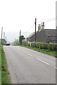
B3081 entering Cann Common
The village, not the common.
Image: © Toby
Taken: 14 Apr 2007
0.20 miles