IMAGES TAKEN NEAR TO
Whitsbury, FORDINGBRIDGE, SP6 3QX
Introduction
This page details the photographs taken nearby to SP6 3QX by members of the Geograph project.
The Geograph project started in 2005 with the aim of publishing, organising and preserving representative images for every square kilometre of Great Britain, Ireland and the Isle of Man.

There are currently over 7.5m images from over14,400 individuals and you can help contribute to the project by visiting https://www.geograph.org.uk
Image Map
Images are licensed for reuse under creativecommons.org/licenses/by-sa/2.0
Notes
- Clicking on the map will re-center to the selected point.
- The higher the marker number, the further away the image location is from the centre of the postcode.
Image Listing (6 Images Found)
Images are licensed for reuse under creativecommons.org/licenses/by-sa/2.0
Image
Details
Distance
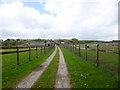
1

Whitsbury, Lower Farm
Judging from the signage (dangerous horses) and barn effluent, part of Whitsbury Stud.
Image: © Mike Faherty
Taken: 21 May 2010
0.01 miles
2
Whitsbury, stud farm
Whitsbury Manor Stud, seen from Long Steeple Lane. http://whitsburymanorstud.co.uk/
Image: © Mike Faherty
Taken: 9 May 2013
0.07 miles
3

Whitsbury, yew trees
Deemed significant enough by OS to be shown on OS Explorer, a pair of yew trees, the lefthand one almost hidden, right in full view; on Long Steeple Lane.
Image: © Mike Faherty
Taken: 21 May 2010
0.10 miles
4

Whitsbury, mares & foals
The fields and paddocks around Lower Farm enclose breeding stock from Whitsbury Stud. http://www.whitsburymanorstud.co.uk/
Image: © Mike Faherty
Taken: 21 May 2010
0.13 miles
5
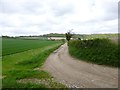
Whitsbury, farm road
From Long Steeple Lane to Down Farm.
Image: © Mike Faherty
Taken: 9 May 2013
0.18 miles
6
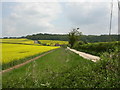
Breamore, Down Farm
The crop at this time of year would appear to be rape seed.
Image: © Mike Faherty
Taken: 21 May 2010
0.22 miles