IMAGES TAKEN NEAR TO
Rockbourne, FORDINGBRIDGE, SP6 3PA
Introduction
This page details the photographs taken nearby to SP6 3PA by members of the Geograph project.
The Geograph project started in 2005 with the aim of publishing, organising and preserving representative images for every square kilometre of Great Britain, Ireland and the Isle of Man.

There are currently over 7.5m images from over14,400 individuals and you can help contribute to the project by visiting https://www.geograph.org.uk
Image Map
Images are licensed for reuse under creativecommons.org/licenses/by-sa/2.0
Notes
- Clicking on the map will re-center to the selected point.
- The higher the marker number, the further away the image location is from the centre of the postcode.
Image Listing (7 Images Found)
Images are licensed for reuse under creativecommons.org/licenses/by-sa/2.0
Image
Details
Distance
1
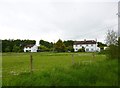
Rockbourne, cottages
Off the access road to Tenantry Farm.
Image: © Mike Faherty
Taken: 29 May 2013
0.02 miles
2
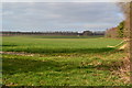
Sunlit field, looking towards Rockbourne Down
Image: © David Martin
Taken: 21 Mar 2015
0.15 miles
3
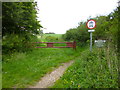
Rockbourne, barrier
Preventing vehicles accessing the restricted byway to Whitsbury Down.
Image: © Mike Faherty
Taken: 29 May 2013
0.16 miles
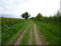
4
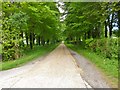
Rockbourne, farm access road
To Tenantry Farm.
Image: © Mike Faherty
Taken: 29 May 2013
0.17 miles
5
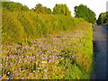
Meadow cranesbill near Rockbourne
One of the loveliest of wild flowers, meadow cranesbill is found in great abundance in the south of England. The flowers are usually blue, and often a very deep blue on chalky soil, but pink and even white are sometimes seen. Here it is growing beside the road to Rockbourne.
Image: © Maigheach-gheal
Taken: 26 Jun 2011
0.20 miles
6
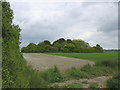
Duck's Nest long barrow, Rockbourne
Looking east at the tree-covered long barrow mound from the by-way that crosses the chalk ridge. The barrow mound is about 50m long, but it's hard to tell when it is this overgrown.
Image: © Jim Champion
Taken: 29 May 2005
0.21 miles
7
Rockbourne, byway
From Whitsbury Down to Tidpit.
Image: © Mike Faherty
Taken: 29 May 2013
0.22 miles