IMAGES TAKEN NEAR TO
Martin, FORDINGBRIDGE, SP6 3LT
Introduction
This page details the photographs taken nearby to SP6 3LT by members of the Geograph project.
The Geograph project started in 2005 with the aim of publishing, organising and preserving representative images for every square kilometre of Great Britain, Ireland and the Isle of Man.

There are currently over 7.5m images from over14,400 individuals and you can help contribute to the project by visiting https://www.geograph.org.uk
Image Map (Loading...)


Getting Data...Please wait
Leaflet Map data © OpenStreetMap
Images are licensed for reuse under creativecommons.org/licenses/by-sa/2.0
Notes
- Clicking on the map will re-center to the selected point.
- The higher the marker number, the further away the image location is from the centre of the postcode.
Image Listing (4 Images Found)
Images are licensed for reuse under creativecommons.org/licenses/by-sa/2.0
Image
Details
Distance
1
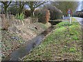
Entering Martin
Martin is a small village, whether that is measured by acres, houses or people. Set at the western most point of Hampshire it touches the borders of both Dorset and Wiltshire, of which it was part until boundary changes in 1895. The village lies at the head of the valley carrying the winterbourne River Allen, and is in the New Forest Conservation Area.
Image: © Maigheach-gheal
Taken: 23 Feb 2009
0.10 miles
2
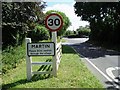
Martin
The village sign now includes the new website address! http://www.martin-pc.newforest.gov.uk
Image: © Nigel Freeman
Taken: 21 Aug 2006
0.11 miles
3
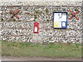
Martin: postbox № SP6 356, Townsend
This little postbox serves the northern end of the village and is emptied at 4pm on weekdays and 10:15am on Saturdays.
Image: © Chris Downer
Taken: 15 Feb 2009
0.24 miles
4
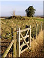
Long barrow, north of Martin
The mound beyond the gate is the mutilated remains of a long barrow on a hill to the north of Martin.
Image: © Jim Champion
Taken: 27 Jan 2008
0.24 miles