IMAGES TAKEN NEAR TO
Hale, FORDINGBRIDGE, SP6 2RQ
Introduction
This page details the photographs taken nearby to SP6 2RQ by members of the Geograph project.
The Geograph project started in 2005 with the aim of publishing, organising and preserving representative images for every square kilometre of Great Britain, Ireland and the Isle of Man.

There are currently over 7.5m images from over14,400 individuals and you can help contribute to the project by visiting https://www.geograph.org.uk
Image Map
Images are licensed for reuse under creativecommons.org/licenses/by-sa/2.0
Notes
- Clicking on the map will re-center to the selected point.
- The higher the marker number, the further away the image location is from the centre of the postcode.
Image Listing (16 Images Found)
Images are licensed for reuse under creativecommons.org/licenses/by-sa/2.0
Image
Details
Distance
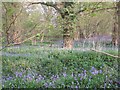
1
Forest Edge, seen from footpath to the north
Image: © David Martin
Taken: 30 Jun 2018
0.05 miles
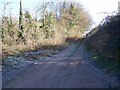
2
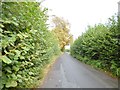
Downton, Moot Lane
Country lane from Woodgreen to Downton. The chestnut tree in the distance will not have its leaves for much longer.
Image: © Mike Faherty
Taken: 8 Oct 2014
0.12 miles
3
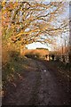
Lane and bridleway to Lodge Farm House, nr. Downton
The woodland on the left is named Church Close Copse.
Image: © Peter Facey
Taken: 10 Dec 2007
0.12 miles
4
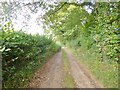
Downton, bridleway
Bridleway and farm road from Lodge Farm to Moot Lane.
Image: © Mike Faherty
Taken: 8 Oct 2014
0.12 miles
6
Bridleway from Moot Lane
The bridleway leaves Moot Lane and heads for North Charford and Woodfalls.
Image: © Maigheach-gheal
Taken: 3 Jan 2009
0.14 miles
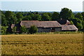
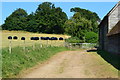
7
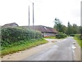
Hale, barn
At Searchfield Farm, on Moot Lane.
Image: © Mike Faherty
Taken: 8 Oct 2014
0.14 miles
8
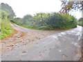
Downton, junction
Left, bridleway and farm road to Lodge Farm; right, Moot Lane, to Woodgreen.
Image: © Mike Faherty
Taken: 8 Oct 2014
0.15 miles
10
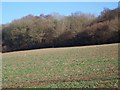
Root crop and woodland near Downton
The shooting pegs in the field indicate that the pheasants will be driven from the woodland over the guns in the field.
Image: © Maigheach-gheal
Taken: 3 Jan 2009
0.15 miles