IMAGES TAKEN NEAR TO
Queen Street, FORDINGBRIDGE, SP6 2RD
Introduction
This page details the photographs taken nearby to Queen Street, SP6 2RD by members of the Geograph project.
The Geograph project started in 2005 with the aim of publishing, organising and preserving representative images for every square kilometre of Great Britain, Ireland and the Isle of Man.

There are currently over 7.5m images from over14,400 individuals and you can help contribute to the project by visiting https://www.geograph.org.uk
Image Map (Loading...)


Getting Data...Please wait
Leaflet Map data © OpenStreetMap
Images are licensed for reuse under creativecommons.org/licenses/by-sa/2.0
Notes
- Clicking on the map will re-center to the selected point.
- The higher the marker number, the further away the image location is from the centre of the postcode.
Image Listing (7 Images Found)
Images are licensed for reuse under creativecommons.org/licenses/by-sa/2.0
Image
Details
Distance
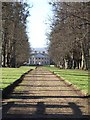
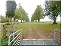
1
Avenue of trees, looking away from Hale House
Image: © David Martin
Taken: 21 Mar 2010
0.21 miles
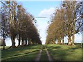
2
Hale House Drive
The continuation of the drive looking away from the house.
Image: © Peter Beaven
Taken: 29 Apr 2007
0.21 miles
3
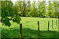
Paddock near Home Farm
Home Farm is part of the Hale House estate. It is a multi-use farm. The paddocks run parallel to the entrance avenue to the house.
Image: © Graham Horn
Taken: 28 Apr 2009
0.24 miles
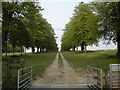
4
Hale, avenue
Lime trees along the drive from Hale House to Hatchet Lodge.
Image: © Mike Faherty
Taken: 8 Oct 2014
0.24 miles
5
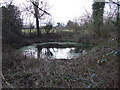
Pond by Picket Well
This pond is about 15 metres North of Picket Well and slightly higher.
Image: © Lorraine and Keith Bowdler
Taken: 19 Feb 2010
0.24 miles
6
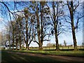
Avenue of trees, Hale House
Here looking away from the house: the avenue is crossed by a lane beyond the white house but continues for another kilometre
Image: © David Martin
Taken: 21 Mar 2010
0.25 miles