IMAGES TAKEN NEAR TO
Carters Close, FORDINGBRIDGE, SP6 2NU
Introduction
This page details the photographs taken nearby to Carters Close, SP6 2NU by members of the Geograph project.
The Geograph project started in 2005 with the aim of publishing, organising and preserving representative images for every square kilometre of Great Britain, Ireland and the Isle of Man.

There are currently over 7.5m images from over14,400 individuals and you can help contribute to the project by visiting https://www.geograph.org.uk
Image Map (11 Images)


Leaflet Map data © OpenStreetMap
Images are licensed for reuse under creativecommons.org/licenses/by-sa/2.0
Notes
- Clicking on the map will re-center to the selected point.
- The higher the marker number, the further away the image location is from the centre of the postcode.
Image Listing (11 Images Found)
Images are licensed for reuse under creativecommons.org/licenses/by-sa/2.0
Image
Details
Distance
1
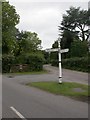
Hale, fingerpost
One of many erected in the New Forest National Park over the last 15 years; tapering post, finial incorporating stylised ponies and trees. This one is dated 2005.
Image: © Mike Faherty
Taken: 24 Sep 2010
0.07 miles
2
Hale, cattle grid
Leaving the New Forest open grazing area.
Image: © Mike Faherty
Taken: 24 Sep 2010
0.08 miles
3
Hale and Pace
I was at Hale when I got a call saying that Sunday dinner was ready, so I had to increase my pace.
Image: © william
Taken: 1 May 2011
0.08 miles
4
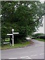
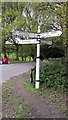
Hale, fingerpost
At the junction of Hale Purlieu and Tethering Drove; one of many erected in the New Forest National Park over the last 15 years; tapering post, finial incorporating stylised ponies and trees. This one is dated 2005.
Image: © Mike Faherty
Taken: 24 Sep 2010
0.09 miles
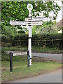
5
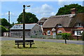
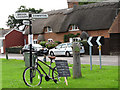
Old Direction Sign - Signpost by Tethering Drove, Hale Parish
Annulus finial - 4 arms; Hampshire Parish halo by the UC road, in parish of Hale (New Forest District), Hale, junction of Hale Purlieu with Tethering Drove, at crossroads.
To be surveyed
Milestone Society National ID: HA_SU1919
Image: © Milestone Society
Taken: Unknown
0.09 miles
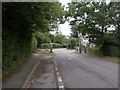
6
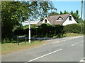
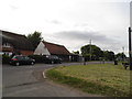
Road Junction, Hale
This road junction is on the Hale Purlieu Road. Hale Purlieu is an area of heath and valley bog with typical flora and fauna,
Image: © Stuart Buchan
Taken: 9 Jun 2006
0.10 miles
7
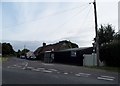
Thatched cottage beside triangular green
Image: © David Martin
Taken: 15 Jun 2018
0.23 miles
8
Forest Road at the junction of Hale Lane
Image: © David Howard
Taken: 16 Jun 2018
0.24 miles
10
Looking for a lover
The village of Lover is a popular place to post Valentines cards.
Image: © william
Taken: 29 Aug 2010
0.25 miles