IMAGES TAKEN NEAR TO
Hale, FORDINGBRIDGE, SP6 2NQ
Introduction
This page details the photographs taken nearby to SP6 2NQ by members of the Geograph project.
The Geograph project started in 2005 with the aim of publishing, organising and preserving representative images for every square kilometre of Great Britain, Ireland and the Isle of Man.

There are currently over 7.5m images from over14,400 individuals and you can help contribute to the project by visiting https://www.geograph.org.uk
Image Map
Images are licensed for reuse under creativecommons.org/licenses/by-sa/2.0
Notes
- Clicking on the map will re-center to the selected point.
- The higher the marker number, the further away the image location is from the centre of the postcode.
Image Listing (6 Images Found)
Images are licensed for reuse under creativecommons.org/licenses/by-sa/2.0
Image
Details
Distance
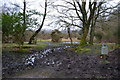
2
The Forest Road south of Whiteshoot Farm
Image: © Stuart Logan
Taken: 30 May 2012
0.05 miles
4
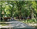
Tethering Drove
The scene at the eastern end of Tethering Drove, close to the junction with the Forest Road.
On a very warm day a good number of ponies had gathered in the shade, blocking the road. They seemed reluctant to move, so that the driver of the red Mini had to wait some minutes before being able to pass through.
Image: © Stefan Czapski
Taken: 4 Sep 2013
0.09 miles
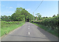
5
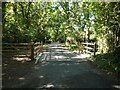
Cattle grid, Tethering Drove
Just west of the point where Tethering Drove meets the Forest Road.
Image: © Stefan Czapski
Taken: 4 Sep 2013
0.12 miles
