IMAGES TAKEN NEAR TO
Hale Purlieu, FORDINGBRIDGE, SP6 2NN
Introduction
This page details the photographs taken nearby to SP6 2NN by members of the Geograph project.
The Geograph project started in 2005 with the aim of publishing, organising and preserving representative images for every square kilometre of Great Britain, Ireland and the Isle of Man.

There are currently over 7.5m images from over14,400 individuals and you can help contribute to the project by visiting https://www.geograph.org.uk
Image Map (6 Images)


Getting Data...Please wait
Leaflet Map data © OpenStreetMap
Images are licensed for reuse under creativecommons.org/licenses/by-sa/2.0
Notes
- Clicking on the map will re-center to the selected point.
- The higher the marker number, the further away the image location is from the centre of the postcode.
Image Listing (6 Images Found)
Images are licensed for reuse under creativecommons.org/licenses/by-sa/2.0
Image
Details
Distance
1
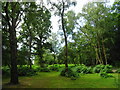
Hale Purlieu
Woodland on edge of former manorial waste grazed under traditional commoners' rights. A purlieu is disafforested lands on the edge of the Royal Forest.
Image: © John M
Taken: 23 Jun 2018
0.11 miles
3
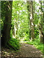
Bridleway near Hale
The bridleway takes walkers and riders through woodland towards Hale Farm.
Image: © Maigheach-gheal
Taken: 29 Jun 2011
0.17 miles
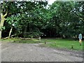
5

Traffic calming New Forest style
On the minor road bordering Hale Purlieu.
Image: © Jon Bryant
Taken: 30 May 2005
0.22 miles
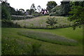
6
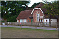
Hale Primary School
Overlooking Hatchet Green.
Image: © David Martin
Taken: 28 Jun 2020
0.23 miles