IMAGES TAKEN NEAR TO
Godshill Wood, FORDINGBRIDGE, SP6 2LT
Introduction
This page details the photographs taken nearby to SP6 2LT by members of the Geograph project.
The Geograph project started in 2005 with the aim of publishing, organising and preserving representative images for every square kilometre of Great Britain, Ireland and the Isle of Man.

There are currently over 7.5m images from over14,400 individuals and you can help contribute to the project by visiting https://www.geograph.org.uk
Image Map (Loading...)


Getting Data...Please wait
Leaflet Map data © OpenStreetMap
Images are licensed for reuse under creativecommons.org/licenses/by-sa/2.0
Notes
- Clicking on the map will re-center to the selected point.
- The higher the marker number, the further away the image location is from the centre of the postcode.
Image Listing (10 Images Found)
Images are licensed for reuse under creativecommons.org/licenses/by-sa/2.0
Image
Details
Distance
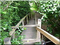
1
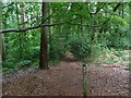
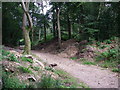
Godshill, woodland
On the footpath from Image to Godshill Wood; beech, with some oak and pine.
Image: © Mike Faherty
Taken: 30 Jun 2011
0.08 miles
2
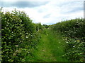
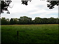
Godshill, footpath
Path and farm track from Folds Farm to Godshill village, between fields.
Image: © Mike Faherty
Taken: 30 Jun 2011
0.08 miles
3
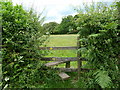
Godshill, stile
At the start of a path from Image across fields and woodland towards Godshill Wood.
Image: © Mike Faherty
Taken: 30 Jun 2011
0.10 miles
4
Godshill, footpath junction
Left, to Folds Farm; ahead, towards Frankenbury.
Image: © Mike Faherty
Taken: 30 Jun 2011
0.16 miles
5
Godshill, stiles and footbridge
An unusual arrangement on the footpath to Folds Farm, over a stream feeding into River Avon: at this end, the top rail lifts; at the other, a pinch stile.
Image: © Mike Faherty
Taken: 30 Jun 2011
0.17 miles
7
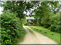
Godshill, Brook Cottage
On the footpath from Folds Farm; presumably named after the stream hidden in scrub to the right.
Image: © Mike Faherty
Taken: 30 Jun 2011
0.20 miles
8
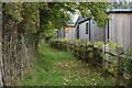
Footpath beside Sandy Balls Holiday Village
Image: © David Martin
Taken: 13 Nov 2021
0.22 miles
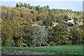
9
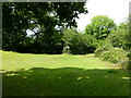
Frankenbury hill fort
The flat area enclosed within Frankenbury, or Godmans Cap Camp, now pasture and part of Folds Farm.
Image: © Barry Deakin
Taken: 3 Aug 2007
0.22 miles
10
Rubble dump in the woods
Rubble piled high around the tree trunks between the Sandy Balls sewage plant and the Ram Valley nature reserve (Image).
Image: © Barry Deakin
Taken: 3 Aug 2007
0.24 miles