IMAGES TAKEN NEAR TO
School Lane, FORDINGBRIDGE, SP6 2LF
Introduction
This page details the photographs taken nearby to School Lane, SP6 2LF by members of the Geograph project.
The Geograph project started in 2005 with the aim of publishing, organising and preserving representative images for every square kilometre of Great Britain, Ireland and the Isle of Man.

There are currently over 7.5m images from over14,400 individuals and you can help contribute to the project by visiting https://www.geograph.org.uk
Image Map (Loading...)


Getting Data...Please wait
Leaflet Map data © OpenStreetMap
Images are licensed for reuse under creativecommons.org/licenses/by-sa/2.0
Notes
- Clicking on the map will re-center to the selected point.
- The higher the marker number, the further away the image location is from the centre of the postcode.
Image Listing (28 Images Found)
Images are licensed for reuse under creativecommons.org/licenses/by-sa/2.0
Image
Details
Distance
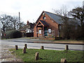
2
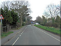
Godshill, Lampton Lodge
On Southampton Road. The building does not resemble a lodge, but a school; old OS maps confirm that it was the village school. Now residential.
Image: © Mike Faherty
Taken: 19 Oct 2014
0.15 miles
4
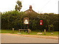
Godshill: postbox № SP6 426 and noticeboard
The easternmost of the three postboxes in Godshill stands next to a parish noticeboard, opposite the pub. It is emptied finally at 4:30pm on weekdays and at 10:15am on Saturdays.
Image: © Chris Downer
Taken: 15 Aug 2009
0.15 miles
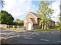
5
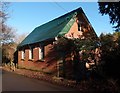
Former Godshill Congregational Chapel
Erected in 1830. Now being converted into a private residence.
Image: © Michael FORD
Taken: Unknown
0.16 miles
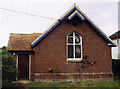
6
Godshill, St. Giles'
Small parish church on Southampton Road: http://www.avonvalleypartnership.org.uk/churches/godshill/
Image: © Mike Faherty
Taken: 19 Oct 2014
0.17 miles
8
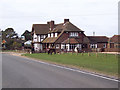
The Fighting Cocks, Godshill
The sign for the pub Image
Image: © Maigheach-gheal
Taken: 5 Mar 2007
0.18 miles
9
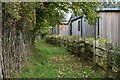
Footpath beside Sandy Balls Holiday Village
Image: © David Martin
Taken: 13 Nov 2021
0.19 miles
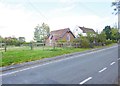
10
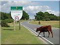
17 animal casualties so far in 2006
The B3078 road, also known as Roger Penny Way, is the main road across the north of the New Forest. At either end (here in Godshill and also at Wittensford near Cadnam) it features these large signboards which give drivers a reminder that many commoners' animals are killed on this road every year. The commoners' animals (cattle, ponies, donkeys, and at certain times of the year pigs) have right of way on the unfenced roads - any accident involving one of these animals must be reported to the police.
Image: © Nigel Freeman
Taken: 21 Aug 2006
0.19 miles