IMAGES TAKEN NEAR TO
Bickton, FORDINGBRIDGE, SP6 2HA
Introduction
This page details the photographs taken nearby to SP6 2HA by members of the Geograph project.
The Geograph project started in 2005 with the aim of publishing, organising and preserving representative images for every square kilometre of Great Britain, Ireland and the Isle of Man.

There are currently over 7.5m images from over14,400 individuals and you can help contribute to the project by visiting https://www.geograph.org.uk
Image Map (Loading...)


Getting Data...Please wait
Leaflet Map data © OpenStreetMap
Images are licensed for reuse under creativecommons.org/licenses/by-sa/2.0
Notes
- Clicking on the map will re-center to the selected point.
- The higher the marker number, the further away the image location is from the centre of the postcode.
Image Listing (32 Images Found)
Images are licensed for reuse under creativecommons.org/licenses/by-sa/2.0
Image
Details
Distance
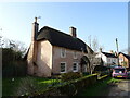
2
Thatch at Bickton
The majority of the cottages in the hamlet are thatched.
Image: © Maigheach-gheal
Taken: 13 Jan 2009
0.04 miles

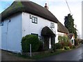
6
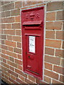
Bickton: postbox № SP6 139
This Edward VII-reign postbox is set into the wall of a house at the bottom of the main street. Its final collection times are 4pm on weekdays and 10:30am on Saturdays.
Image: © Chris Downer
Taken: 18 May 2013
0.05 miles
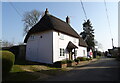
7
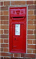
Edward VII postbox, Bickton
Postbox No. SP6 139.
Image: © JThomas
Taken: 22 Mar 2022
0.06 miles
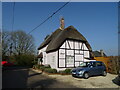
8
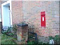
Edward VII postbox, Bickton
Set into the wall of a brick built cottage in the hamlet of Bickton.
Image: © Maigheach-gheal
Taken: 13 Jan 2009
0.06 miles
9
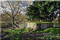
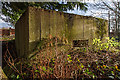
WWII Hampshire - Ringwood Stop Line, Avon Valley - Fordingbridge anti-tank island (11)
-
Bickton Mill pillbox type FW3/26: DoB ID: S0012671
This pillbox at Bickton Mill would appear to have been the most southerly of the Fordingbridge defences, and the sole survivor of two pillboxes that were constructed at this locality. Built into a bank overlooking the river, the area in front that it commands is now a commercial fish farm.
The town of Fordingbridge became a major component of the Ringwood Stop Line in 1940 when it was designated an 'Anti-tank Island'. The perceived invasion threat was from the south and west, and accordingly it was where most of the defences were built. The town and its surroundings has managed to retain a fair number of its WWII defences, although of these, inevitably perhaps, it's the comparatively indestructable brick and concrete pillboxes that remain today. Having said that, it's therefore a mystery why there are for example no surviving anti-tank blocks, or any sign of the several rare L-plan infantry section posts (holding 8 - 10 men) that were located to the north and south of the town. One possible survivor is listed on the DoB Archive on private land south of the parish church. Like the others it seems to have vanished, and probably lies buried under a large mound of earth and scrub at its designated location.
Image
Image: © Mike Searle
Taken: 13 Jan 2017
0.07 miles
10
WWII Hampshire - Ringwood Stop Line, Avon Valley - Fordingbridge anti-tank island (12)
-
Bickton Mill pillbox type FW3/26: DoB ID: S0012671
The pillbox is a typical type 26, square in plan without an interior ricochet wall, with loops placed centrally in three of the walls, and an entrance with a loophole in the north wall.
Image
Image: © Mike Searle
Taken: 13 Jan 2017
0.07 miles