IMAGES TAKEN NEAR TO
Salisbury Road, FORDINGBRIDGE, SP6 2ED
Introduction
This page details the photographs taken nearby to Salisbury Road, SP6 2ED by members of the Geograph project.
The Geograph project started in 2005 with the aim of publishing, organising and preserving representative images for every square kilometre of Great Britain, Ireland and the Isle of Man.

There are currently over 7.5m images from over14,400 individuals and you can help contribute to the project by visiting https://www.geograph.org.uk
Image Map
Images are licensed for reuse under creativecommons.org/licenses/by-sa/2.0
Notes
- Clicking on the map will re-center to the selected point.
- The higher the marker number, the further away the image location is from the centre of the postcode.
Image Listing (82 Images Found)
Images are licensed for reuse under creativecommons.org/licenses/by-sa/2.0
Image
Details
Distance
3
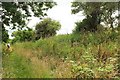
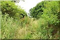
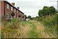
Former railway line, Breamore
Heading south from the old station at Breamore. A bit of a safari through the long grass, but no chance of missing the way. This, the dismantled Salisbury and Dorset Junction Railway line, is the boundary (as far as Lower Burgate) of the New Forest National Park, which begins on the left.
Image: © Derek Harper
Taken: 16 Jul 2016
0.07 miles
4
No trains at this station.
Breamore station has not seen a train since the 1960s.
Image: © william
Taken: 1 May 2011
0.07 miles
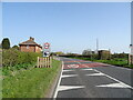
5
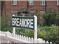
Refurbished Station Sign
The remains of this closed (since 1964) station have been cleaned up recently.
Image: © mike smith
Taken: 27 Oct 2006
0.07 miles
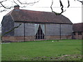
6
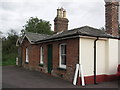
Former Station Building at Breamore
This former station was in use as offices by Hampshire County Council when the photograph was taken.
Image: © mike smith
Taken: 27 Oct 2006
0.07 miles
7
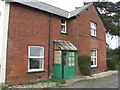
Station House at Breamore
This building, still a home, was the station master's house.
Image: © mike smith
Taken: 27 Oct 2006
0.07 miles
8
Former railway line, Breamore
A little further along the path shown in Image Unsuitable for hay fever sufferers. Fortunately I'm sufficiently full of strong cider and some medication or other that it makes little difference.
Image: © Derek Harper
Taken: 16 Jul 2016
0.08 miles
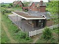
9
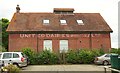
Former dairy, Breamore Station
With a ghost sign, "United Dairies Wholesale Ltd", on the wall. The building is now home to Cain Bio-Engineering Ltd. Seen from the railway path.
Image: © Derek Harper
Taken: 16 Jul 2016
0.09 miles
10
Former railway line, Breamore
The dismantled Salisbury and Dorset Junction Railway line, with some new housing near the former station building. See Image] for a reverse view from the road bridge ahead. This is the boundary of the New Forest National Park (right).
Image: © Derek Harper
Taken: 16 Jul 2016
0.10 miles