IMAGES TAKEN NEAR TO
North Street, FORDINGBRIDGE, SP6 2DQ
Introduction
This page details the photographs taken nearby to North Street, SP6 2DQ by members of the Geograph project.
The Geograph project started in 2005 with the aim of publishing, organising and preserving representative images for every square kilometre of Great Britain, Ireland and the Isle of Man.

There are currently over 7.5m images from over14,400 individuals and you can help contribute to the project by visiting https://www.geograph.org.uk
Image Map (Loading...)


Getting Data...Please wait
Leaflet Map data © OpenStreetMap
Images are licensed for reuse under creativecommons.org/licenses/by-sa/2.0
Notes
- Clicking on the map will re-center to the selected point.
- The higher the marker number, the further away the image location is from the centre of the postcode.
Image Listing (4 Images Found)
Images are licensed for reuse under creativecommons.org/licenses/by-sa/2.0
Image
Details
Distance
1
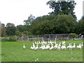
Christmas lunch, Breamore
For some, the alternative to turkey is roast goose for their Christmas lunch.
Image: © Maigheach-gheal
Taken: 19 Oct 2010
0.03 miles
2
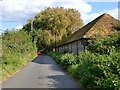
Lane on the Breamore Estate
The long, low building - brick-built with bands of knapped flint - was probably once a milking shed.
Image: © Stefan Czapski
Taken: 19 Sep 2012
0.05 miles
3
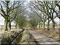
Hampshire Lane
An avenue leading to North Street and Breamore Park which can be glimpsed through the trees to the right.
The drainage ditch belies the valley floor situation of this road.
Image: © Jonathan Billinger
Taken: 4 Mar 2010
0.23 miles
4

St Mary's Church, Breamore
The church building originates from the late 10th century: it is exceptionally long for a Saxon structure.
Image: © Jim Champion
Taken: 10 Jul 2005
0.24 miles