IMAGES TAKEN NEAR TO
Salisbury Road, FORDINGBRIDGE, SP6 2DJ
Introduction
This page details the photographs taken nearby to Salisbury Road, SP6 2DJ by members of the Geograph project.
The Geograph project started in 2005 with the aim of publishing, organising and preserving representative images for every square kilometre of Great Britain, Ireland and the Isle of Man.

There are currently over 7.5m images from over14,400 individuals and you can help contribute to the project by visiting https://www.geograph.org.uk
Image Map (Loading...)


Getting Data...Please wait
Leaflet Map data © OpenStreetMap
Images are licensed for reuse under creativecommons.org/licenses/by-sa/2.0
Notes
- Clicking on the map will re-center to the selected point.
- The higher the marker number, the further away the image location is from the centre of the postcode.
Image Listing (7 Images Found)
Images are licensed for reuse under creativecommons.org/licenses/by-sa/2.0
Image
Details
Distance
1
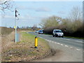
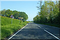
A338, looking north
Across the North Street junction, towards Salisbury.
A solar-powered gizmo on a pole stands to the left behind its protective yellow bollard. What is this infrastructure?
Image: © Jonathan Billinger
Taken: 4 Mar 2010
0.12 miles
4
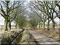
Road from Breamore Park
Looking towards the junction with the A338 Salisbury to Ringwood Road.
Image: © Jonathan Billinger
Taken: 4 Mar 2010
0.17 miles
5
A338 Salisbury Road
Towards Salisbury.
Image: © Robin Webster
Taken: 30 May 2021
0.17 miles
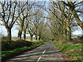
6
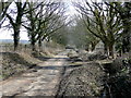
Hampshire Lane
An avenue leading to North Street and Breamore Park which can be glimpsed through the trees to the right.
The drainage ditch belies the valley floor situation of this road.
Image: © Jonathan Billinger
Taken: 4 Mar 2010
0.19 miles