IMAGES TAKEN NEAR TO
Upper Street, FORDINGBRIDGE, SP6 2BY
Introduction
This page details the photographs taken nearby to Upper Street, SP6 2BY by members of the Geograph project.
The Geograph project started in 2005 with the aim of publishing, organising and preserving representative images for every square kilometre of Great Britain, Ireland and the Isle of Man.

There are currently over 7.5m images from over14,400 individuals and you can help contribute to the project by visiting https://www.geograph.org.uk
Image Map
Images are licensed for reuse under creativecommons.org/licenses/by-sa/2.0
Notes
- Clicking on the map will re-center to the selected point.
- The higher the marker number, the further away the image location is from the centre of the postcode.
Image Listing (46 Images Found)
Images are licensed for reuse under creativecommons.org/licenses/by-sa/2.0
Image
Details
Distance
1
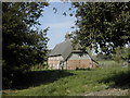
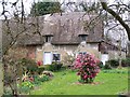
Pontins Cottage
Pontin's Cottage - occupied for much of the 20th century by members of the Ponting family (not Pontin!).
Image: © Peter Beaven
Taken: 22 Apr 2007
0.02 miles
2
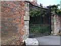
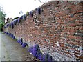
Gate and wall, The Rookery, Breamore
The wall and gate piers date from the 17th century. There is an Ordnance Survey bench mark near the left hand pier.
Image: © Maigheach-gheal
Taken: 6 Jul 2010
0.03 miles
3
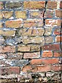
Bench Mark, The Rookery
The bench mark is on the east face of the wall. For a view of the wall http://www.geograph.org.uk/photo/2019279 and for further information on the cut mark http://www.bench-marks.org.uk/bm35236
A bench mark is an Ordnance Survey arrowhead sign found on walls, bridges, churches and specially erected triangulation pillars where the altitude above sea-level has been accurately measured by surveyors. The arrowhead points to a horizontal line above it which marks the exact altitude.
With rivets and pivots there is no datum (horizontal line) cut, the pointed-to horizontal surface defining the datum height.
Image: © Maigheach-gheal
Taken: 6 Jul 2010
0.04 miles
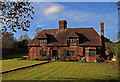
4
Pontings Cottage, Breamore
This timber framed cottage was built in the early 17th century.
Image: © Maigheach-gheal
Taken: 14 Apr 2009
0.04 miles
5
Wall, Breamore
Grade II listed, 17th century wall to the Rookery.
Image: © Maigheach-gheal
Taken: 14 Apr 2009
0.05 miles
6
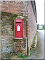
George VI Postbox, Breamore
The postbox is located in the end wall of the Rookery.
Image: © Maigheach-gheal
Taken: 14 Apr 2009
0.06 miles
7
Tudor Lodge - Breamore
A former rectory, now a private house, that may also serve as the estate office for Breamore House. Oddly named, as this is essentially a C17 timber frame house with C20 restoration and additions, and is Grade II Listed.
Image: © Mike Searle
Taken: 29 Nov 2007
0.07 miles
8
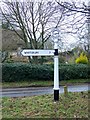
Finger post, Breamore
The sign, which is just in square, has recently been repainted. I am sure it had more arms in the past!
Image: © Maigheach-gheal
Taken: 15 Jan 2010
0.08 miles
9
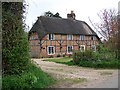
Thatched cottage on corner of Rookery Lane
Image: © David Martin
Taken: 28 Mar 2010
0.09 miles
10
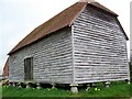
Granary, Breamore
Built in the early 19th century this timber frame granary stands on 21 staddles and has a half-hipped roof.
Image: © Maigheach-gheal
Taken: 14 Apr 2009
0.11 miles