IMAGES TAKEN NEAR TO
Woodgreen Road, FORDINGBRIDGE, SP6 2AE
Introduction
This page details the photographs taken nearby to Woodgreen Road, SP6 2AE by members of the Geograph project.
The Geograph project started in 2005 with the aim of publishing, organising and preserving representative images for every square kilometre of Great Britain, Ireland and the Isle of Man.

There are currently over 7.5m images from over14,400 individuals and you can help contribute to the project by visiting https://www.geograph.org.uk
Image Map (Loading...)


Getting Data...Please wait
Leaflet Map data © OpenStreetMap
Images are licensed for reuse under creativecommons.org/licenses/by-sa/2.0
Notes
- Clicking on the map will re-center to the selected point.
- The higher the marker number, the further away the image location is from the centre of the postcode.
Image Listing (108 Images Found)
Images are licensed for reuse under creativecommons.org/licenses/by-sa/2.0
Image
Details
Distance
2
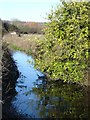
Breamore: heading into the village from Woodgreen
The road from Woodgreen crosses the River Avon by Breamore Mill and turns sharply on its way to Breamore village. A burst of sunshine - a rarity this last few days - brings out some autumn colour in the background.
Image: © Chris Downer
Taken: 21 Nov 2010
0.02 miles
3

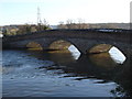
River Avon near Breamore
Looking upstream from the plaque shown in Image Between the willows on the left is a side turning to a salmon run by Breamore Mill. The river forms the boundary of the New Forest National Park and the parish boundary between Breamore (other bank) and Woodgreen.
Image: © Derek Harper
Taken: 16 Jul 2016
0.02 miles
4
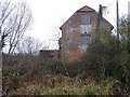
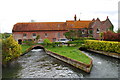
Breamore Mill
The gable end of the building with pillbox attached. For a closer view of the pillbox Image
Image: © Maigheach-gheal
Taken: 6 Feb 2012
0.03 miles
5
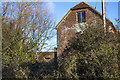
Pillbox, Breamore Mill
The pillbox is attached to the mill.
Image: © Maigheach-gheal
Taken: 6 Feb 2012
0.03 miles
6
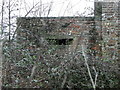
WWII Hampshire - Ringwood Stop Line, Avon Valley - Breamore Mill (6)
-
Pillbox (variant) type FW3/26: DoB ID: S0000488
The second pillbox is a type 26 built onto the north west corner of the Mill. It overlooks the Breamore to Woodgreen road just short of the approach to the bridge over the western channel of the Avon. The matching brickwork was no accident, it would have been deliberately chosen in order to blend with the existing building. Access is on the north east side with a low entrance protected by a blast wall. There are embrasures on the south west and north west sides enabling gunfire to be directed onto the road at both short and long ranges, as well as enfilade fire towards the river. Protection for the rear of the Mill would have been from the embrasure on the north east side. Action from here would have been coordinated with a third pillbox north of the Mill.
Image
Image: © Mike Searle
Taken: 13 Jan 2017
0.03 miles
7
WWII Hampshire - Ringwood Stop Line, Avon Valley - Breamore Mill (7)
-
Pillbox (variant) type FW3/26: DoB ID: S0000488
A closer view of the pillbox. Note the remains of false brickwork pointing on the concrete lintel and sill of the embrasure intended as part of a disguise. The pillbox was undoubtedly camouflaged with the addition of camo-netting, and possibly a false pitched roof.
Image
Image: © Mike Searle
Taken: 13 Jan 2017
0.03 miles
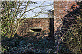
8
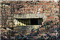
WWII Hampshire - Ringwood Stop Line, Avon Valley - Breamore Mill (8)
-
Pillbox (variant) type FW3/26: DoB ID: S0000488
A close-up of the south west embrasure. Note for camouflage purposes the false pointing on the concrete lintel and sill of the embrasure.
Image
Image: © Mike Searle
Taken: 13 Jan 2017
0.03 miles