IMAGES TAKEN NEAR TO
Woodgreen Road, FORDINGBRIDGE, SP6 2AA
Introduction
This page details the photographs taken nearby to Woodgreen Road, SP6 2AA by members of the Geograph project.
The Geograph project started in 2005 with the aim of publishing, organising and preserving representative images for every square kilometre of Great Britain, Ireland and the Isle of Man.

There are currently over 7.5m images from over14,400 individuals and you can help contribute to the project by visiting https://www.geograph.org.uk
Image Map (Loading...)


Getting Data...Please wait
Leaflet Map data © OpenStreetMap
Images are licensed for reuse under creativecommons.org/licenses/by-sa/2.0
Notes
- Clicking on the map will re-center to the selected point.
- The higher the marker number, the further away the image location is from the centre of the postcode.
Image Listing (126 Images Found)
Images are licensed for reuse under creativecommons.org/licenses/by-sa/2.0
Image
Details
Distance
1
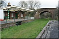
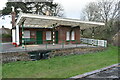
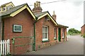
Former Breamore railway station
The disused trackbed is now open as a footpath for approximately one mile north and one mile south of the former station.
Image: © David Martin
Taken: 18 Dec 2021
0.02 miles
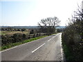
3
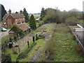
Former railway line, Breamore
The dismantled Salisbury and Dorset Junction Railway line, seen from the road from Woodgreen. The houses are on the site of the former Breamore Halt; the old station building is on the extreme right (see also Image] and Image). The line is the boundary (as far as Lower Burgate) of the New Forest National Park, which is to the left.
Image: © Derek Harper
Taken: 16 Jul 2016
0.02 miles
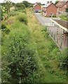
4
Old station building, Breamore Halt
A little overgrown compared to Image, but that goes with the season. On the left are five new houses built beside the Old Dairy.
Image: © Derek Harper
Taken: 16 Jul 2016
0.02 miles
6
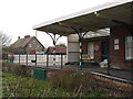
Breamore Station (remains)
View southward, towards Broadstone and Poole; ex-London & south Western, Salisbury - Broadstone - (Poole - Bournemouth) line. The station was closed completely with the line on 4/5/64.
Image: © Ben Brooksbank
Taken: 10 Sep 1973
0.03 miles
7
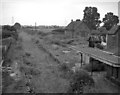
Breamore Station, Platform 2
Looking down the line towards Fordingbridge. It's being put to good use as a vegetable patch.
Image: © Judith Green
Taken: 24 Mar 2007
0.03 miles
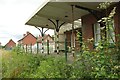
8
Breamore Station
Former station on the Broadstone Junction to Salisbury line; according to the interpretation board, built 1864, closed 1964, renovated privately 2005. http://www.disused-stations.org.uk/b/breamore/
Image: © Mike Faherty
Taken: 11 Oct 2014
0.03 miles
9
Old station building, Breamore Halt
Differing styles of brickwork in this old station by the dismantled Salisbury and Dorset Junction Railway line.
Image: © Derek Harper
Taken: 16 Jul 2016
0.03 miles
10
Breamore Station
It seems to be quite well cared for.
Image: © Judith Green
Taken: 24 Mar 2007
0.03 miles