IMAGES TAKEN NEAR TO
Bruyn Road, FORDINGBRIDGE, SP6 1QZ
Introduction
This page details the photographs taken nearby to Bruyn Road, SP6 1QZ by members of the Geograph project.
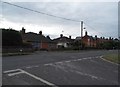
The Geograph project started in 2005 with the aim of publishing, organising and preserving representative images for every square kilometre of Great Britain, Ireland and the Isle of Man.

There are currently over 7.5m images from over14,400 individuals and you can help contribute to the project by visiting https://www.geograph.org.uk
Image Map
Images are licensed for reuse under creativecommons.org/licenses/by-sa/2.0
Notes
- Clicking on the map will re-center to the selected point.
- The higher the marker number, the further away the image location is from the centre of the postcode.
Image Listing (117 Images Found)
Images are licensed for reuse under creativecommons.org/licenses/by-sa/2.0
Image
Details
Distance
1
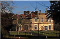
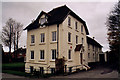
Burgate Manor - The Game Conservancy - Fordingbridge
The U.K. Headquarters of the Game & Wildlife Conservation Trust (formerly The Game Conservancy Trust) is situated at Burgate Manor, just off the A338 outside Fordingbridge http://www.gct.org.uk/default.asp.
Burgate House as it used to be known, is a small C18 country house, with C19 alterations. Grade II Listed.
Image: © Mike Searle
Taken: 29 Nov 2007
0.06 miles
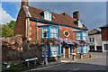
2
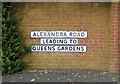
Can you see the join?
It looks like three signs but look at the lower two's borders, there was originally the one leading to sign which has been cut in half with one laid beneath the other. It was probably a different wall before and didn't fit the new one so had to divide the sign rather than waste it.
Image: © David Howard
Taken: 16 Jun 2018
0.07 miles
3
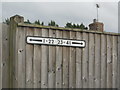
House number signs on Lyster Road, Fordingbridge
For unknown reasons this was moved a few feet along the fence since taken by Google Maps.
Image: © David Howard
Taken: 16 Jun 2018
0.08 miles
4
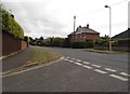
Salisbury Road at the junction of Lyster Road
Two large trees have been removed from the front of the house opposite
Image: © David Howard
Taken: 16 Jun 2018
0.09 miles
5
Salisbury Road at the junction of Lyster Road
Image: © David Howard
Taken: 16 Jun 2018
0.10 miles
6
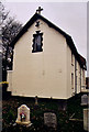
St Mary & St Philip Roman Catholic Church, Fordingbridge
Erected in 1872 as Our Lady of the Seven Dolours.
Image: © Michael FORD
Taken: Unknown
0.11 miles
7
St Mary & St Philip, Fordingbridge
Erected in 1872 as Our Lady of the Seven Dolours for the Roman Catholics.
Image: © Michael FORD
Taken: Unknown
0.11 miles
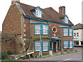
9
Old manor house
Covered with Wisteria,which is in bloom
Image: © william
Taken: 28 Apr 2009
0.12 miles
10
Where have all the flowers gone?
When I last put a picture of this house on this site in 2009,it was covered in flowers.
Image: © william
Taken: 24 Apr 2013
0.14 miles