IMAGES TAKEN NEAR TO
Crook Hill, SALISBURY, SP5 5LJ
Introduction
This page details the photographs taken nearby to Crook Hill, SP5 5LJ by members of the Geograph project.
The Geograph project started in 2005 with the aim of publishing, organising and preserving representative images for every square kilometre of Great Britain, Ireland and the Isle of Man.

There are currently over 7.5m images from over14,400 individuals and you can help contribute to the project by visiting https://www.geograph.org.uk
Image Map
Images are licensed for reuse under creativecommons.org/licenses/by-sa/2.0
Notes
- Clicking on the map will re-center to the selected point.
- The higher the marker number, the further away the image location is from the centre of the postcode.
Image Listing (13 Images Found)
Images are licensed for reuse under creativecommons.org/licenses/by-sa/2.0
Image
Details
Distance
5
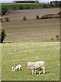
Ewe and lambs, Norrington Farm
The ewes and lambs graze in the early spring sunshine.
Image: © Maigheach-gheal
Taken: 27 Feb 2009
0.09 miles
6
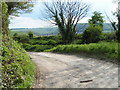
Cycle route 20 heading east near Windmill Hill
Image: © Rob Purvis
Taken: 7 May 2010
0.10 miles
8
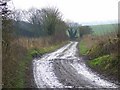
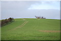
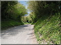
Track to Trow Down
The muddy tracks heads towards the downs passing farm buildings on the way.
Image: © Maigheach-gheal
Taken: 19 Feb 2009
0.13 miles