IMAGES TAKEN NEAR TO
Alvediston, SALISBURY, SP5 5LH
Introduction
This page details the photographs taken nearby to SP5 5LH by members of the Geograph project.
The Geograph project started in 2005 with the aim of publishing, organising and preserving representative images for every square kilometre of Great Britain, Ireland and the Isle of Man.

There are currently over 7.5m images from over14,400 individuals and you can help contribute to the project by visiting https://www.geograph.org.uk
Image Map
Images are licensed for reuse under creativecommons.org/licenses/by-sa/2.0
Notes
- Clicking on the map will re-center to the selected point.
- The higher the marker number, the further away the image location is from the centre of the postcode.
Image Listing (9 Images Found)
Images are licensed for reuse under creativecommons.org/licenses/by-sa/2.0
Image
Details
Distance
1
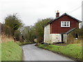
Trow Cottage, Alvediston
The cottage stands beside the C11 between Alvediston and Berwick St John.
Image: © Maigheach-gheal
Taken: 22 Feb 2012
0.01 miles
2
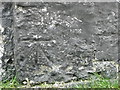
Bench Mark, Trow Cottage
The Ordnance Survey bench mark is to be found on the northwest wall of the cottage. For a wider view of the building Image and for further information on the cut mark and others in the area http://www.bench-marks.org.uk/bm41542
Image: © Maigheach-gheal
Taken: 22 Feb 2012
0.01 miles
3
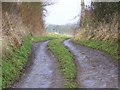
Footpath to Norrington
Starting as a farm track, the footpath takes walkers to Norrington Manor. The path is in the very corner of the grid square.
Image: © Maigheach-gheal
Taken: 19 Feb 2009
0.02 miles
4
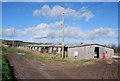
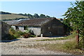
Sheep shack
Building used for separating, lambing, shearing, etc.
Image: © Toby
Taken: 11 Feb 2007
0.10 miles
9
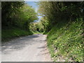
Cycle route 20 heading east near Windmill Hill
Image: © Rob Purvis
Taken: 7 May 2010
0.25 miles