IMAGES TAKEN NEAR TO
Newtown, SALISBURY, SP5 5DS
Introduction
This page details the photographs taken nearby to Newtown, SP5 5DS by members of the Geograph project.
The Geograph project started in 2005 with the aim of publishing, organising and preserving representative images for every square kilometre of Great Britain, Ireland and the Isle of Man.

There are currently over 7.5m images from over14,400 individuals and you can help contribute to the project by visiting https://www.geograph.org.uk
Image Map (Loading...)


Getting Data...Please wait
Leaflet Map data © OpenStreetMap
Images are licensed for reuse under creativecommons.org/licenses/by-sa/2.0
Notes
- Clicking on the map will re-center to the selected point.
- The higher the marker number, the further away the image location is from the centre of the postcode.
Image Listing (122 Images Found)
Images are licensed for reuse under creativecommons.org/licenses/by-sa/2.0
Image
Details
Distance

2
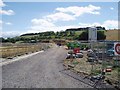
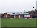
New Primary School at Broad Chalke
Being built (2006) for the growing community.
Image: © Nigel Freeman
Taken: 21 Aug 2006
0.09 miles
3
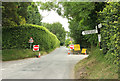
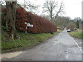
Junction, Broad Chalke
Almost a crossroads, though the right turn is a bridleway up Church Bottom and is not quite opposite The Causeway, which is the left turn.
Image: © Derek Harper
Taken: 1 Jul 2018
0.11 miles
4
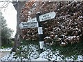
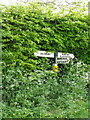
Old Direction Sign - Signpost by Bury Lane, Broad Chalke
Pyramid top finial - 3 arms; Wiltshire wooden by the UC road, in parish of Broad Chalke (Salisbury District), Broad Chalke, at crossroads S of Causeway Bridge.
Surveyed
Milestone Society National ID: WI_SU0425.
Image: © Milestone Society
Taken: Unknown
0.11 miles
5
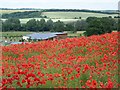
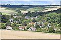
Field poppies, Broad Chalke
On the lower slopes of Knighton Hill poppies grow in profusion. This plant is used in herbal medicine for coughs and throat infections. Common Poppies, sometimes called Field Poppies, are a very striking scarlet colour. They are often seen in great numbers in cornfields or on road verges.
In the valley is Broad Chalke Primary School.
Image: © Maigheach-gheal
Taken: 29 Jun 2010
0.11 miles
6
Broad Chalke, fingerpost
Traditional Wiltshire fingerpost at the southern end of the village, with a square black and white striped wooden post.
Image: © Mike Faherty
Taken: 23 Jan 2010
0.12 miles
9
Finger post, Broad Chalke
The sign tries to hide in the hedge, but just there is just enough showing to keep travellers on the right route.
Image: © Maigheach-gheal
Taken: 5 May 2011
0.13 miles
10
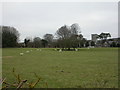
Broad Chalke, sheep
Sheep grazing in a field to the South of the parish church and village hall.
Image: © Mike Faherty
Taken: 23 Jan 2010
0.13 miles