IMAGES TAKEN NEAR TO
Butlers Yard, SALISBURY, SP5 5DQ
Introduction
This page details the photographs taken nearby to Butlers Yard, SP5 5DQ by members of the Geograph project.
The Geograph project started in 2005 with the aim of publishing, organising and preserving representative images for every square kilometre of Great Britain, Ireland and the Isle of Man.

There are currently over 7.5m images from over14,400 individuals and you can help contribute to the project by visiting https://www.geograph.org.uk
Image Map (Loading...)


Getting Data...Please wait
Leaflet Map data © OpenStreetMap
Images are licensed for reuse under creativecommons.org/licenses/by-sa/2.0
Notes
- Clicking on the map will re-center to the selected point.
- The higher the marker number, the further away the image location is from the centre of the postcode.
Image Listing (167 Images Found)
Images are licensed for reuse under creativecommons.org/licenses/by-sa/2.0
Image
Details
Distance
1
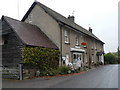
Post Office, Broad Chalke
Earmarked for closure.
Image: © Maigheach-gheal
Taken: 24 Jan 2008
0.02 miles
2

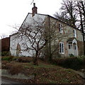
Weather vane, Broad Chalke
The weather vane is to be found on a house near the Post Office.
Weather vanes have always been more than just a wind direction device. Created by skilled craftsman, there is true artistic expression in the varied designs. Initially wood vanes were carved by carpenters or furniture makers, and iron, copper and tin ones were forged by the local blacksmith or tinsmith. In the 19th century weather vanes started to be mass-produced from moulds.
Image: © Maigheach-gheal
Taken: 20 Feb 2012
0.03 miles
3
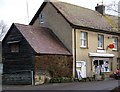
Broad Chalke: butcher and post office
The post office at Broad Chalke is housed within this butcher's shop. The absence of a postbox very nearby suggests strongly that it was previously elsewhere and moved here when the previous premises – village store, perhaps – closed.
Image: © Chris Downer
Taken: 1 Nov 2008
0.03 miles
4
Bena Cottage, Broad Chalke
Bena Cottage stands on the junction of a byway and South Street. There is an Ordnance Survey bench mark on the north angle.
Image: © Maigheach-gheal
Taken: 20 Feb 2012
0.04 miles
5
Bench Mark, Bena Cottage
The Ordnance Survey bench mark is hidden behind the branches of a garden shrub. For a view of the building Image and for further information on the cut mark and others in the area http://www.bench-marks.org.uk/bm41519
Image: © Maigheach-gheal
Taken: 20 Feb 2012
0.04 miles
6
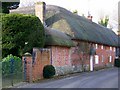
Reddish House Cottages
A pair of late 17th century thatched cottages.
Image: © Maigheach-gheal
Taken: 10 Feb 2010
0.08 miles
7
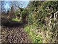
Muddy footpath in Broad Chalke
The footpath takes walkers along the Ebble Valley to Fifield Bavant.
Image: © Maigheach-gheal
Taken: 28 Feb 2007
0.10 miles
8
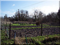
Allotments at Broad Chalke
Use of land as allotment gardens goes back to before the reign of Elizabeth I, but it was during the World Wars that allotments became really popular with city-dwellers and country people alike.
Fresh fruit and vegetables were in short supply, so driven by the government Dig for Victory campaign, townfolk dug up public parks, playing fields and village greens to grow their own.
Image: © Maigheach-gheal
Taken: 28 Feb 2007
0.11 miles
9

Broad Chalke - Rhea
A rare bird indeed - on a smallholding in Broad Chalke, Wiltshire.
Image: © Colin Smith
Taken: 18 Aug 2015
0.12 miles
10
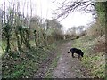
Bridleway, Broad Chalke
The bridleway takes walkers and riders from Broad Chalke to Bowerchalke.
Image: © Maigheach-gheal
Taken: 24 Jan 2008
0.12 miles