IMAGES TAKEN NEAR TO
Ashmore, SALISBURY, SP5 5AF
Introduction
This page details the photographs taken nearby to SP5 5AF by members of the Geograph project.
The Geograph project started in 2005 with the aim of publishing, organising and preserving representative images for every square kilometre of Great Britain, Ireland and the Isle of Man.

There are currently over 7.5m images from over14,400 individuals and you can help contribute to the project by visiting https://www.geograph.org.uk
Image Map (Loading...)


Getting Data...Please wait
Leaflet Map data © OpenStreetMap
Images are licensed for reuse under creativecommons.org/licenses/by-sa/2.0
Notes
- Clicking on the map will re-center to the selected point.
- The higher the marker number, the further away the image location is from the centre of the postcode.
Image Listing (110 Images Found)
Images are licensed for reuse under creativecommons.org/licenses/by-sa/2.0
Image
Details
Distance
1
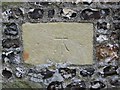
Bench Mark, Ashmore
The bench mark is to be found on the eastern wall of St Nicholas Church Image and http://www.bench-marks.org.uk/bm33543
A bench mark is an Ordnance Survey arrowhead sign found on walls, bridges, churches and specially erected concrete posts where the altitude above sea-level has been accurately measured by surveyors. The arrowhead points to a horizontal line above it which marks the exact altitude.
Image: © Maigheach-gheal
Taken: 17 Mar 2010
0.01 miles
2
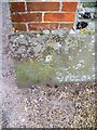
Bench Mark, Ashmore
The bench mark is to be found on No 1 Church Cottage. It is a genuine OS mark, but no records are to be found at present. http://www.bench-marks.org.uk/bm33548
Image: © Maigheach-gheal
Taken: 17 Mar 2010
0.01 miles
3
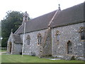
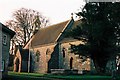
Ashmore, St Nicholas
Parish church, mainly C19 restored, with an arch that might be C13. As seen on a wet summer's day. English Heritage-listed, http://www.imagesofengland.org.uk/Details/Default.aspx?id=102850&mode=adv
Image: © Mike Faherty
Taken: 26 Aug 2009
0.01 miles
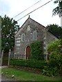
6
Former Wesleyan Chapel, High Street, Ashmore
Grade II listed, with a date stone for 1855.
Image: © Tim Heaton
Taken: 10 Feb 2020
0.03 miles
7
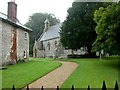
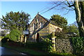
Ashmore Church
Ashmore is a beautiful village, with thatched cottages grouped around a large duck pond. It is the highest village in Dorset at over 700 feet above sea level.
Image: © Maigheach-gheal
Taken: 6 Mar 2005
0.04 miles
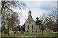
9
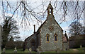
The Church of St Nicholas at Ashmore
The church was built in 1874 and is of a chequrework of greensand and flint.
Image: © Maigheach-gheal
Taken: 6 Mar 2005
0.04 miles