IMAGES TAKEN NEAR TO
Lower Road, SALISBURY, SP5 4NQ
Introduction
This page details the photographs taken nearby to Lower Road, SP5 4NQ by members of the Geograph project.
The Geograph project started in 2005 with the aim of publishing, organising and preserving representative images for every square kilometre of Great Britain, Ireland and the Isle of Man.

There are currently over 7.5m images from over14,400 individuals and you can help contribute to the project by visiting https://www.geograph.org.uk
Image Map
Images are licensed for reuse under creativecommons.org/licenses/by-sa/2.0
Notes
- Clicking on the map will re-center to the selected point.
- The higher the marker number, the further away the image location is from the centre of the postcode.
Image Listing (118 Images Found)
Images are licensed for reuse under creativecommons.org/licenses/by-sa/2.0
Image
Details
Distance
1
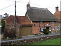
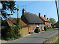
Box Cottage, Homington
The thatched cottage is built of Flemish bond brick and has 1726 on the date stone. For a view of the date stone Image
Image: © Maigheach-gheal
Taken: 14 Feb 2012
0.01 miles
2
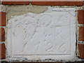
Date stone, Homington
The date stone is set into the front wall of Box Cottage. For a wider view of the cottage Image
Image: © Maigheach-gheal
Taken: 14 Feb 2012
0.01 miles
3
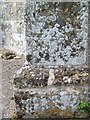
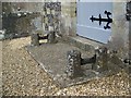
Bench Mark, Church of St Mary the Virgin
Bench mark on the buttress of the tower. For a view of the tower Image and http://www.bench-marks.org.uk/bm34429
A bench mark is an Ordnance Survey arrowhead sign found on walls, bridges, churches and specially erected triangulation pillars where the altitude above sea-level has been accurately measured by surveyors. The arrowhead points to a horizontal line above it which marks the exact altitude.
With rivets and pivots there is no datum (horizontal line) cut, the pointed-to horizontal surface defining the datum height.
Image: © Maigheach-gheal
Taken: 18 May 2010
0.01 miles
4
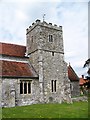
Tower, Church of St Mary the Virgin
The crenellated tower has a Ordnance Survey bench mark on the southwest buttress.
Image: © Maigheach-gheal
Taken: 18 May 2010
0.01 miles
5
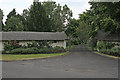
Thatched walls forming property entrance, Lower Road, Homington
These rendered and thatched walls form the entrance to a substantial house whose name I cannot read on the photo. A very similar entrance is also to be found in Coombe Bissett.
Image: © Peter Facey
Taken: 28 Jun 2006
0.01 miles
6
Detail, The Church of St Mary the Virgin
Boot scrapers at the main door to the church.
Image: © Maigheach-gheal
Taken: 18 May 2010
0.01 miles
7
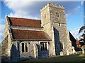
Church of St Mary the Virgin, Homington
The church has its origins in the 12th century with the chancel and nave dating from the 13th century. The tower was built in the 15th century with T H Wyatt undertook further restoration in 1860.
Image: © Maigheach-gheal
Taken: 4 Mar 2008
0.01 miles
8
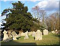
Churchyard, St Mary the Virgin, Homington
The churchyard contains burials from many generations, showing the Church's concern for its parishioners in this life and beyond the grave. The stones tell the history of the Parish and reflect changing attitudes and fashions.
Image: © Maigheach-gheal
Taken: 4 Mar 2008
0.01 miles
10
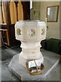
Font, The Church of St Mary the Virgin
The Victorian font stands just inside of the west door.
Image: © Maigheach-gheal
Taken: 14 Feb 2012
0.02 miles