IMAGES TAKEN NEAR TO
High Road, SALISBURY, SP5 4AL
Introduction
This page details the photographs taken nearby to High Road, SP5 4AL by members of the Geograph project.
The Geograph project started in 2005 with the aim of publishing, organising and preserving representative images for every square kilometre of Great Britain, Ireland and the Isle of Man.

There are currently over 7.5m images from over14,400 individuals and you can help contribute to the project by visiting https://www.geograph.org.uk
Image Map
Images are licensed for reuse under creativecommons.org/licenses/by-sa/2.0
Notes
- Clicking on the map will re-center to the selected point.
- The higher the marker number, the further away the image location is from the centre of the postcode.
Image Listing (15 Images Found)
Images are licensed for reuse under creativecommons.org/licenses/by-sa/2.0
Image
Details
Distance
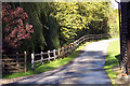
1
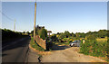
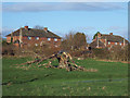
Cottage near Bishopstone
Image: © Derek Harper
Taken: 30 Jun 2018
0.04 miles
2
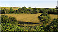
Ebble valley near Bishopstone
Like Image, a view towards the River Ebble from the road along the valley. Footpath BSTO 15 runs along the field just below the camera, past the trees in the foreground.
Image: © Derek Harper
Taken: 30 Jun 2018
0.08 miles
3
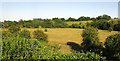
Ebble valley near Bishopstone
Looking left from where Image] was taken. Footpath BSTO 15 runs along the field just below the camera, past the trees in the foreground.
Image: © Derek Harper
Taken: 30 Jun 2018
0.09 miles
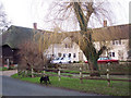
4
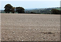
Down the valley
Looking down the Ebble Valley from the bridleway from Bishopstone.
The River Ebble is one of the five rivers of Salisbury. Rising at Alvediston, 12 miles to the west of the city, it then joins the River Avon at Bodenham. Managed by the Ebble Valley Conservation and Fishery Association (EVCAFA) to benefit the fish rather than the fisherman, the River Ebble is one of the Environment Agency's ‘Wild Fisheries Protection Zones’ (WFPZ). This means that the river cannot be stocked with any fish from its source to its confluence with the River Avon.
Image: © Jonathan Kington
Taken: 23 Oct 2011
0.09 miles
6
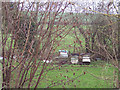
Bee Hives
Hives by the River Ebble.
Image: © Maigheach-gheal
Taken: 30 Dec 2006
0.15 miles
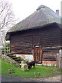
7
Lower Mill
The mill wheel is still housed in the thatched end of the house.
Image: © Maigheach-gheal
Taken: 30 Dec 2006
0.15 miles
8
Lower Mill
The original mill wheel is still housed in this building.
Image: © Maigheach-gheal
Taken: 30 Dec 2006
0.15 miles
9
Mill Lane at Lower Mill, Bishopstone
Image: © Maigheach-gheal
Taken: 13 Oct 2004
0.15 miles
10

A Family of Swans on the River Ebble
The River Ebble is an outstanding little river, just 7 miles long rising due west of Salisbury flowing south easterly through meadows to join the River Avon just south of the cathedral city.
Image: © Maigheach-gheal
Taken: 23 Jan 2005
0.16 miles