IMAGES TAKEN NEAR TO
Downton, SALISBURY, SP5 3QP
Introduction
This page details the photographs taken nearby to SP5 3QP by members of the Geograph project.
The Geograph project started in 2005 with the aim of publishing, organising and preserving representative images for every square kilometre of Great Britain, Ireland and the Isle of Man.

There are currently over 7.5m images from over14,400 individuals and you can help contribute to the project by visiting https://www.geograph.org.uk
Image Map
Images are licensed for reuse under creativecommons.org/licenses/by-sa/2.0
Notes
- Clicking on the map will re-center to the selected point.
- The higher the marker number, the further away the image location is from the centre of the postcode.
Image Listing (12 Images Found)
Images are licensed for reuse under creativecommons.org/licenses/by-sa/2.0
Image
Details
Distance
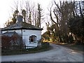
1
Standlynch, Shepherd's Cottage
At a sharp bend on the road from Barford Down to Standlynch.
Image: © Mike Faherty
Taken: 30 Jan 2014
0.01 miles
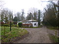
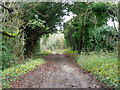
2
Sunset down the lane
Cottage at the junction of five tracks
Image: © David Martin
Taken: 7 Mar 2010
0.02 miles
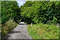
5
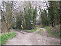
Junction of Byways
Left takes you over Witherington Down and right over Standlynch Down.
Image: © Maigheach-gheal
Taken: 5 Feb 2007
0.04 miles
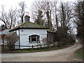
6
Track to Privett Farm
This is also a public footpath.
Image: © Robin Webster
Taken: 18 Dec 2015
0.05 miles
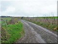
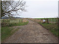
8
Restricted byway to Witherington Down
There was no physical restriction at this end.
Image: © Robin Webster
Taken: 18 Dec 2015
0.09 miles
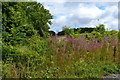
10

Field below Standlynch Down
With Salisbury Cathedral spire just visible in the left distance.
Image: © David Martin
Taken: 26 Jul 2020
0.12 miles