IMAGES TAKEN NEAR TO
Standlynch, SALISBURY, SP5 3QJ
Introduction
This page details the photographs taken nearby to Standlynch, SP5 3QJ by members of the Geograph project.
The Geograph project started in 2005 with the aim of publishing, organising and preserving representative images for every square kilometre of Great Britain, Ireland and the Isle of Man.

There are currently over 7.5m images from over14,400 individuals and you can help contribute to the project by visiting https://www.geograph.org.uk
Image Map
Images are licensed for reuse under creativecommons.org/licenses/by-sa/2.0
Notes
- Clicking on the map will re-center to the selected point.
- The higher the marker number, the further away the image location is from the centre of the postcode.
Image Listing (10 Images Found)
Images are licensed for reuse under creativecommons.org/licenses/by-sa/2.0
Image
Details
Distance
1
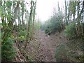
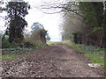
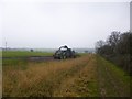
Standlynch, railway trackbed
The former Salisbury & Dorset Junction Railway, closed in 1964: http://www.disused-stations.org.uk/d/downton/index.shtml
Image: © Mike Faherty
Taken: 30 Jan 2014
0.02 miles
2
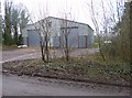
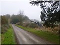
Standlynch, barn
On the road from Barford Down to Standlynch.
Image: © Mike Faherty
Taken: 30 Jan 2014
0.03 miles
4
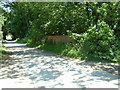
Road close to Standlynch Farm
In the photo you can see the railway bridge which crosses the dismantled track. There is also a bridleway which runs parallel to the track, the sign can just be seen.
Image: © Stuart Buchan
Taken: 9 Jun 2006
0.08 miles
5
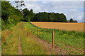
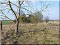
Bridleway at Four Gates
The bridleway heads south towards Barford Down alongside the dismantled railway line.
Image: © Maigheach-gheal
Taken: 5 Feb 2007
0.09 miles
6
Standlynch, barn
On the road from Barford Down to Standlynch.
Image: © Mike Faherty
Taken: 30 Jan 2014
0.10 miles
7
Disused railway line, near Standlynch
This is the trackbed looking north: the cutting south of this spot is heavily overgrown
Image: © David Martin
Taken: 13 Mar 2010
0.10 miles
8
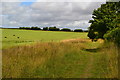
Footpath north from Four Gates, beside former railway
Image: © David Martin
Taken: 26 Jul 2020
0.16 miles
10
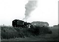
Standlynch - The Beeching Belle
Although taken in black & white on a poor-resolution Brownie 127 camera, this is one of my all-time favourite photos. For me, this picture taken near dusk on a dreary autumn day in 1965 somehow portrays the unremitting gloom of this era. The demolition train somehow symbolises the death of Britain's rural railways. The Salisbury to Bournemouth railway line was closed in March 1964. Demolition started at the West Moors end in March 1965 and finished at Alderbury Junction in late 1965. The locals nicknamed this demolition train the "Beeching Belle" after Dr Richard Beeching, who consigned much of Britain's railway network to the dustbin.
Image: © Dave Bevis
Taken: 26 Oct 1965
0.23 miles