IMAGES TAKEN NEAR TO
Downton, SALISBURY, SP5 3QG
Introduction
This page details the photographs taken nearby to SP5 3QG by members of the Geograph project.
The Geograph project started in 2005 with the aim of publishing, organising and preserving representative images for every square kilometre of Great Britain, Ireland and the Isle of Man.

There are currently over 7.5m images from over14,400 individuals and you can help contribute to the project by visiting https://www.geograph.org.uk
Image Map (Loading...)


Getting Data...Please wait
Leaflet Map data © OpenStreetMap
Images are licensed for reuse under creativecommons.org/licenses/by-sa/2.0
Notes
- Clicking on the map will re-center to the selected point.
- The higher the marker number, the further away the image location is from the centre of the postcode.
Image Listing (4 Images Found)
Images are licensed for reuse under creativecommons.org/licenses/by-sa/2.0
Image
Details
Distance
1
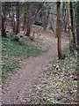
Footpath from Standlynch Farm through Trafalgar Park
Image: © Maigheach-gheal
Taken: 5 Feb 2007
0.13 miles
2
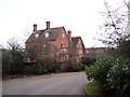
Trafalgar House
Trafalgar House, originally Standlynch Park when it was built in 1733, was acquired by Act of Parliament to commemorate the great victory by Admiral Nelson at the Battle of Trafalgar in 1805 and given to his brother as a lasting tribute to his heirs.
Image: © DACP
Taken: 6 Sep 2006
0.16 miles
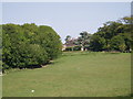
3
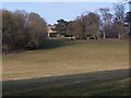
Field below Trafalgar house
The house is visible at the top of the hill
Image: © David Martin
Taken: 13 Mar 2010
0.17 miles