IMAGES TAKEN NEAR TO
Slab Lane, SALISBURY, SP5 3PT
Introduction
This page details the photographs taken nearby to Slab Lane, SP5 3PT by members of the Geograph project.
The Geograph project started in 2005 with the aim of publishing, organising and preserving representative images for every square kilometre of Great Britain, Ireland and the Isle of Man.

There are currently over 7.5m images from over14,400 individuals and you can help contribute to the project by visiting https://www.geograph.org.uk
Image Map (Loading...)


Getting Data...Please wait
Leaflet Map data © OpenStreetMap
Images are licensed for reuse under creativecommons.org/licenses/by-sa/2.0
Notes
- Clicking on the map will re-center to the selected point.
- The higher the marker number, the further away the image location is from the centre of the postcode.
Image Listing (3 Images Found)
Images are licensed for reuse under creativecommons.org/licenses/by-sa/2.0
Image
Details
Distance
1
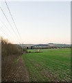
Avon Valley Path approaching Downton
Also shows 33KV electricity lines feeding power to Redlynch electricity substation (behind photographer).
Image: © Peter Facey
Taken: 10 Dec 2007
0.22 miles
2
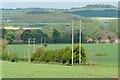
Avon Valley Path
The path runs through farmland well above the river valley on its approach to Downton. In the distance on the hill to the right is Clearbury Ring in Image
Image: © Graham Horn
Taken: 28 Apr 2009
0.24 miles
3
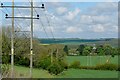
Avon Valley Path approaching Downton
A view from a similar location to this one by Peter Facey Image] (just a few yards closer to Downton). My picture is about four months later and Spring has arrived.
The Avon Valley Path runs from Christchurch to Salisbury, following the river where possible but with frequent excursions into the farmland in the valley on either side, giving views like this.
Image: © Graham Horn
Taken: 28 Apr 2009
0.25 miles