IMAGES TAKEN NEAR TO
Mesh Pond, SALISBURY, SP5 3NQ
Introduction
This page details the photographs taken nearby to Mesh Pond, SP5 3NQ by members of the Geograph project.
The Geograph project started in 2005 with the aim of publishing, organising and preserving representative images for every square kilometre of Great Britain, Ireland and the Isle of Man.

There are currently over 7.5m images from over14,400 individuals and you can help contribute to the project by visiting https://www.geograph.org.uk
Image Map
Images are licensed for reuse under creativecommons.org/licenses/by-sa/2.0
Notes
- Clicking on the map will re-center to the selected point.
- The higher the marker number, the further away the image location is from the centre of the postcode.
Image Listing (30 Images Found)
Images are licensed for reuse under creativecommons.org/licenses/by-sa/2.0
Image
Details
Distance
2
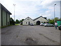
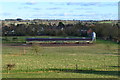
Wick, sports centre
Off Wick Lane; centrepiece of a leisure complex, with Brian Whitehead Sports Centre clubhouse (shown), leisure centre, football and bowls clubs and tennis courts.
Image: © Mike Faherty
Taken: 31 May 2014
0.11 miles
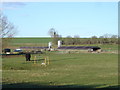
3
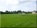
Downton Football Club
Off Wick Lane: http://www.downtonfc.com/
Image: © Mike Faherty
Taken: 31 May 2014
0.12 miles
4
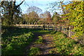
Long shadows across field towards Wick
Image: © David Martin
Taken: 18 Nov 2019
0.13 miles

9
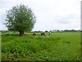
Wick, horse grazing
In fields off Wick Lane.
Image: © Mike Faherty
Taken: 31 May 2014
0.18 miles
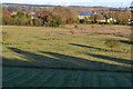
10
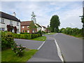
Wick, Wick Lane
Lane from the town centre to Wick and Wick Down, with modern housing, left.
Image: © Mike Faherty
Taken: 31 May 2014
0.18 miles