IMAGES TAKEN NEAR TO
Wick Lane, SALISBURY, SP5 3NH
Introduction
This page details the photographs taken nearby to Wick Lane, SP5 3NH by members of the Geograph project.
The Geograph project started in 2005 with the aim of publishing, organising and preserving representative images for every square kilometre of Great Britain, Ireland and the Isle of Man.

There are currently over 7.5m images from over14,400 individuals and you can help contribute to the project by visiting https://www.geograph.org.uk
Image Map
Images are licensed for reuse under creativecommons.org/licenses/by-sa/2.0
Notes
- Clicking on the map will re-center to the selected point.
- The higher the marker number, the further away the image location is from the centre of the postcode.
Image Listing (18 Images Found)
Images are licensed for reuse under creativecommons.org/licenses/by-sa/2.0
Image
Details
Distance
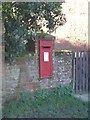
1

Postbox, Wick
A George V reign postbox at Wick Farm Cottages.
Image: © Maigheach-gheal
Taken: 11 Nov 2009
0.00 miles
2
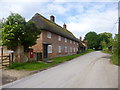
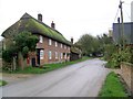
Wick Farm Cottages
Thatched cottages on Wick Lane; listed by English Heritage: http://www.imagesofengland.org.uk/Details/Default.aspx?id=319703&mode=adv
Image: © Mike Faherty
Taken: 31 May 2014
0.03 miles
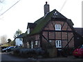
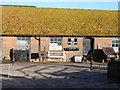
6
Wick Farm Cottages
A pair of early 18th century brick built cottages.
Image: © Maigheach-gheal
Taken: 11 Nov 2009
0.04 miles
8
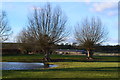
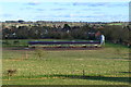
Trees and pond in field beside Wick Lane
Image: © David Martin
Taken: 2 Feb 2013
0.06 miles
9
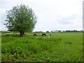
Wick, horse grazing
In fields off Wick Lane.
Image: © Mike Faherty
Taken: 31 May 2014
0.07 miles