IMAGES TAKEN NEAR TO
Eastman Close, SALISBURY, SP5 3LJ
Introduction
This page details the photographs taken nearby to Eastman Close, SP5 3LJ by members of the Geograph project.
The Geograph project started in 2005 with the aim of publishing, organising and preserving representative images for every square kilometre of Great Britain, Ireland and the Isle of Man.

There are currently over 7.5m images from over14,400 individuals and you can help contribute to the project by visiting https://www.geograph.org.uk
Image Map (Loading...)


Getting Data...Please wait
Leaflet Map data © OpenStreetMap
Images are licensed for reuse under creativecommons.org/licenses/by-sa/2.0
Notes
- Clicking on the map will re-center to the selected point.
- The higher the marker number, the further away the image location is from the centre of the postcode.
Image Listing (14 Images Found)
Images are licensed for reuse under creativecommons.org/licenses/by-sa/2.0
Image
Details
Distance
1

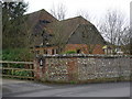
Housing for older people
Only a short walk to the bus stop, post box, doctor's surgery and shops.
Image: © Judith Green
Taken: 6 Mar 2007
0.12 miles
3
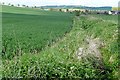
Footpath to Downton
The path towards the village from the south-east runs along field edges. Here it is already well overgrown and we are still in April.
Image: © Graham Horn
Taken: 28 Apr 2009
0.14 miles

5
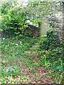
Steps and gate, Downton
This gate is beside the Avon Valley Path as it leaves the environs of Downton.
Image: © Maigheach-gheal
Taken: 28 Apr 2009
0.15 miles
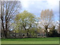
6

Moot Lane, Downton
With turning into Moot Gardens in left foreground.
Image: © Peter Facey
Taken: 10 Dec 2007
0.17 miles
9
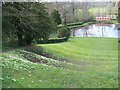
Amphitheatre, Downton Moot Gardens
Looking down from the top of the amphitheatre to the pond.
Image: © Maigheach-gheal
Taken: 8 Apr 2008
0.21 miles
10
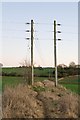
Avon Valley Path east of Downton
The path begins to climb the hill towards Woodfalls Farm. The same line has been taken by these 33KV electricity lines which feed power to Redlynch substation (over horizon) from Salisbury (left) and Mannington (right) substations.
Image: © Peter Facey
Taken: 10 Dec 2007
0.23 miles